by Elena Psyllou, Ph. D, Imperial College London and Co-Lead, Single-Pilot Resource Management and Emerging Technologies Working Group
What are these satellites?
Global Navigation Satellite System (GNSS) refers to a constellation of satellites providing signals from space that transmit positioning and timing data to GNSS receivers. The receivers then use this data to determine location. Examples of GNSS s include the USA’s NAVSTAR Global Positioning System (GPS), Europe’s Galileo, and Russia’s GLONASS.
The performance of GNSS is assessed based on accuracy, integrity, continuity, and availability. This performance can be improved by regional satellite-based augmentation systemsFootnote 1. The U.S. Federal Aviation Administration (FAA) has developed the Wide Area Augmentation System (WAAS) to provide GPS corrections and a certified level of integrity to the aviation industry. The corrections are also available free of charge to civilian users in North America.
The performance of GNSS is assessed based on accuracy, integrity, continuity and availability
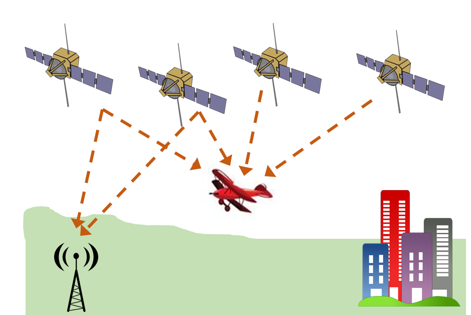
A GNSS receiver calculates its distance from each satellite whose signal it receives (Figure 1), and from these determines its own position in three dimensions, i.e. latitude, longitude, and altitude. Hence, reliable measurements are attributed not only to the GNSS but to the receiver as well.
Technical incapacity
GNSS s have shown exceptional reliability; however, they are still susceptible to technical failure. A recent example is Galileo’s week-long outage in July 2019 with users unable to rely on the system for positioning, navigation, or timing during this period. Because a receiver can rely on more than one GNSS , users of Galileo-enabled devices may not have noticed that anything was amiss. However, the location accuracy might have been degraded and the receivers might have become more vulnerable to interference. Even though the receiver produced measurements during the outage period, the measurements were not really error-free. Another technical failure occurred in 2016Footnote 2 in which the GPS broadcast the wrong time for several hours after an old satellite had been taken out of service, causing problems for cellular networks and digital broadcasters.
Briefly, the key concerns regarding the technical performance of the GNSS s are the following:
- Availability of satellites: The receiver needs to be able to see several satellites to provide a fix. The number of satellites depends on the accuracy and integrity required for the operation. Typically, a minimum of four satellites need to be available.
- Geometry: In addition to being visible, the angular separation of the satellite may be small at certain times giving rise to poor accuracy.
- Terrain shielding: Satellites might be invisible to the receiver at low level, in regions of high ground, or obstacles resulting in the loss of signal or inaccuracies.
- Multi-path reflections: The signal may bounce off hills or structures before arriving at the receiver, producing errors in the aircraft position.
- Interference and jamming: The signal received from the satellite is vulnerable to interference coming from a variety of sources, including radio emissions in nearby bands, intentional or unintentional jamming, and naturally occurring space weather, e.g. solar storms.
- External factors: The owner of the GNSS , e.g. the U.S. Department of Defense for the GPS , might make changes in the system or even switch off the system, resulting in errors. For example, satellites might be moved in order to improve the coverage over a certain area, reducing availability over others.
Did you know that satellites can be invisible to the receiver, causing errors?
How are satellites used in general aviation (GA)?
Identify the aircraft position
In
GA
,
GNSS
systems are primarily used to identify the aircraft position, i.e. the receiver’s position, for navigation, but they can also be used to share the aircraft position with other users, including traffic and air traffic services.
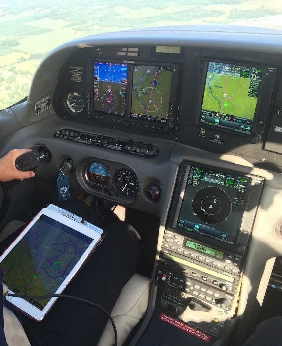
Under VFR , the pilot monitors the flight path by referring to the latitude, longitude, and altitude estimated by the receiver. Examples of such technologies are (Figure 2):
- Fit-in receivers, which can integrate both navigation and communication systems and present the information on a screen (G1000, GTNTM 650)
- External portable receivers that can either plug in (e.g. Bad Elf) or connect wirelessly to a computer on-board
- Built-in receiver of a tablet or mobile phone
The external portable receivers have the advantage of being mountable anywhere in the cockpit as long as the receiver can see satellites, i.e. an unobstructed view of the antenna, and the pilot can read the receiver’s screen. Taking as an example the Bad Elf Bluetooth GPS Receiver, the antenna is located underneath the logo and the device achieves best reception when facing towards the sky with an unobstructed view. Hence, the receiver has to be mounted on its back with its face skyward and perpendicular to the ground in order to better see satellites. Nonetheless, it should be placed in such a location where its screen can still be read from the pilot’s seat.
If the receiver needs to have a clear view of the satellites, where should it be mounted?
Similarly, the tablet also has the flexibility of being mountable to the preference of the pilot and might be put unconsciously on the lap similar to the paper charts on the kneeboard (Figure 3). In this case, the reliability of the tablet’s GNSS receiver can be reduced as the signal travelling from the receiver to the satellites can be obstructed from the aircraft skeleton. This limitation can be overcome by connecting the tablet to an external receiver that is mounted in a place that improves its performance.
Exchange position information
GA
pilots can also share the aircraft position with other users, including aircraft and air traffic services. Under
IFR
in controlled airspace, the position measurements are shared with air traffic services. Automatic dependent surveillance–broadcast (ADS-B) is also based on the traffic-traffic and traffic-air traffic services exchange of information.
Traffic-detection technologies
Assuming a wide use of satellite-based navigation, technologies can enable aircraft to both see and be seen using methods other than visual detection. ADS-B is an example of such technologies. While based on a radar rather than satellites, the benefits of using a technology that detects traffic are evident in gliding. FLARMFootnote 3 is a traffic detection and collision avoidance system that is primarily used by gliders. FLARM enables pilots to detect gliders in the area using the radar signals transmitted from their aircraft. A metal or carbon fibre aircraft will shield the signal. A prerequisite is that the aircraft also carries this system.
Human factors
As seen, the GNSS receivers estimate the position of the aircraft, and these measurements are not error-free. It is up to the user, i.e. the GA pilot, to ensure that the receiver sees the minimum number of satellites unobstructed and that no outage has been reported. In cases of reduced performance of the receiver, the GA pilot still needs to find his/her way to the destination using other navigation means, e.g. visually identify landmarks. Nevertheless, a GNSS only estimates the position that is either presented to the pilot in longitude, latitude, or altitude, or input into another software that visually presents the aircraft position on a moving map, e.g. ForeFlight. While all these technologies seem to do all the work for you, the GA pilot, there are six things that they can’t help you with:
- Selecting waypoints for you
- Getting your gaze off its screen
- Adjusting the aircraft heading for you
- Telling you where the traffic is
- Suggesting a route for the weather
- Telling you when you are tired


