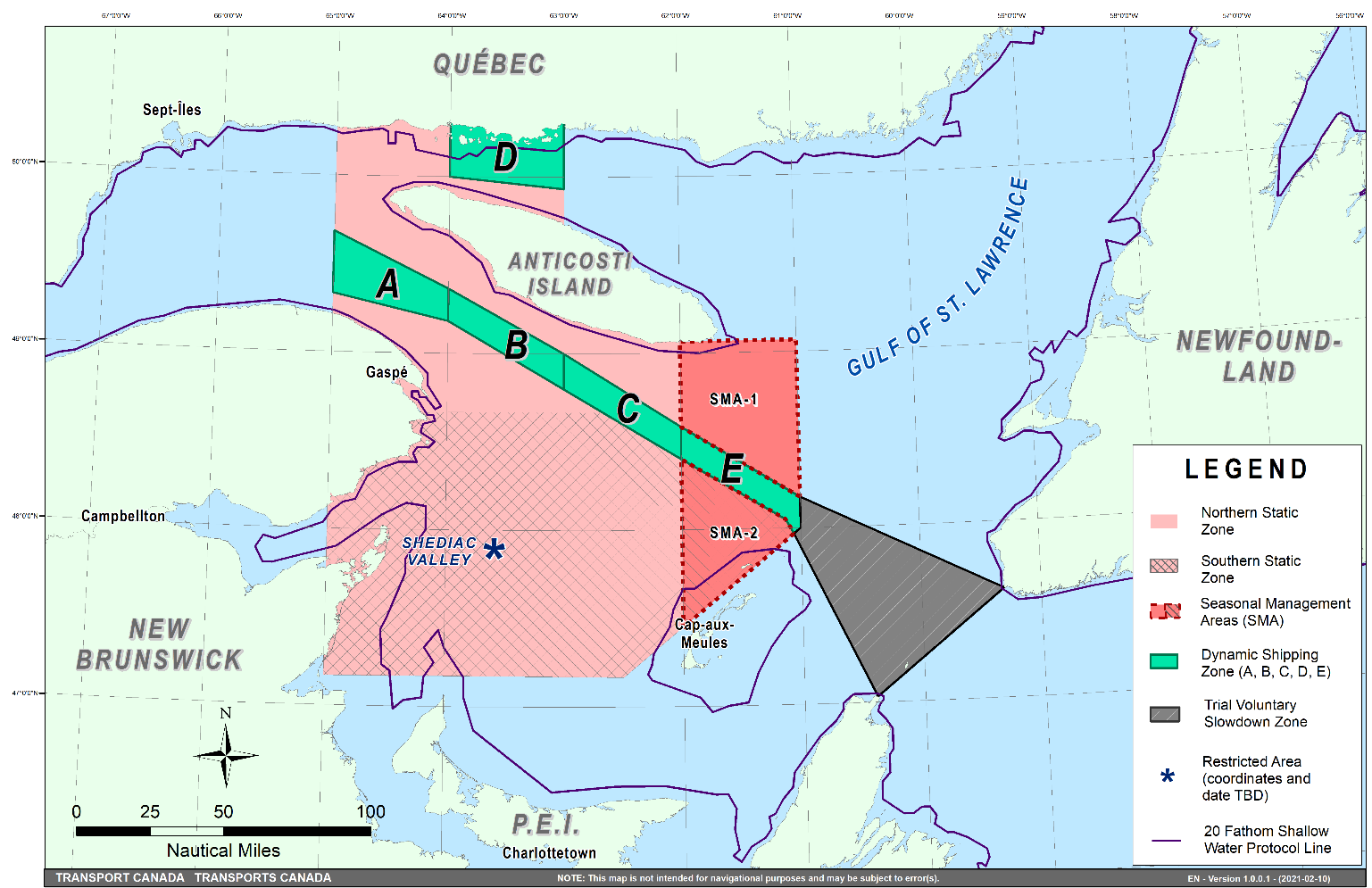
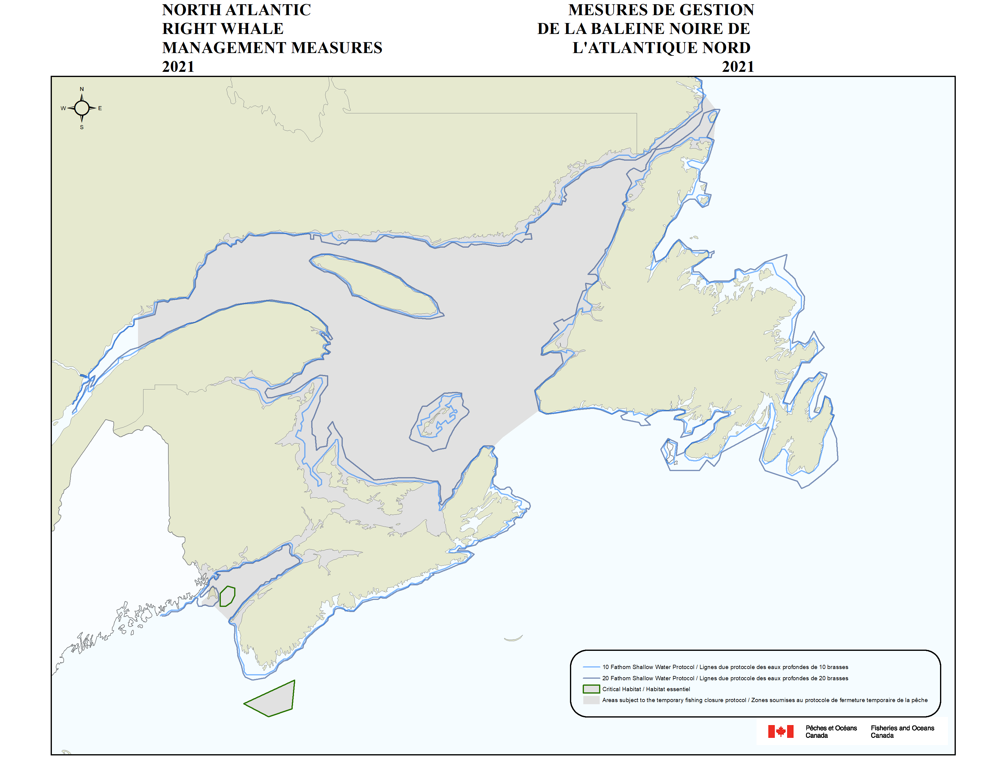
With approximately 366 remaining in the world, North Atlantic right whales are endangered and the Government of Canada continues to take action to protect this iconic species. The 2021 measures remain focused on two main concerns: collision with vessels and entanglement with fishing gear.
Canada’s 2021 measures use the best available science, data, and input from industry, provincial governments, Indigenous communities, academia, non-governmental organizations, and other stakeholders, including partners in the United States.
Managing vessel traffic
Vessel traffic management measures for 2021 aim to more efficiently target risks to North Atlantic right whales from vessel traffic, especially as they migrate in and out of the Gulf of St. Lawrence in greater numbers in the spring and fall, while also maintaining the safety and security of mariners. Building on experience from previous years, the measures incorporate an additional year of data on whale distribution, fishing and marine transportation patterns, feedback from stakeholders, and a robust and varied approach to surveillance.
Vessel traffic management measures in 2021 for all vessels more than 13 metres in length are listed below.
Measures carried over from 2020 that will be re-implemented again this year are as follows:
- A mandatory speed restriction to a maximum of 10 knots when travelling throughout much of the Gulf of St. Lawrence beginning on April 28.
- A mandatory speed restriction to 10 knots for 15 days when a North Atlantic right whale is detected in one of the dynamic shipping zones in the shipping lanes north and south of Anticosti Island. When no North Atlantic right whales are detected in the area, vessels are allowed to travel at safe operational speeds.
- Two seasonal management areas north and south of dynamic shipping zone E from April 28 to June 29, reducing vessel speeds to 10 knots to provide more protection when larger numbers of North Atlantic right whales are expected to be migrating into the Gulf of Lawrence. From June 30 to November 15, vessels will be permitted to travel through the two seasonal management areas at safe operational speeds unless a North Atlantic right whale is detected. If detected, a mandatory speed restriction will be put in place for 15 days.
- A trial voluntary slowdown of 10 knots for vessels traveling through the Cabot Strait from April 28 to June 29, and once again from September 29 to November 15, to provide additional protection when larger numbers of North Atlantic right whales are migrating in or out of the Gulf of St. Lawrence.
- A mandatory restricted area aimed at protecting a large gathering of North Atlantic right whales that, in recent years, has been known to form in the late spring-early summer in and near the Shediac Valley. This restricted area, located east of New Brunswick and north-west of Prince Edward Island, will require that all vessels avoid the area, or, if on a list of exempted vessels reduce their speed to eight knots when travelling through it.
- Fines of up to $250,000 will be issued to vessels that are non-compliant with the mandatory vessel traffic management measures put in place for the 2021 season.
Modified measures for 2021:
- The mandatory restricted area in and near the Shediac Valley will be refined by size, location, and duration to better protect right whales that are anticipated to be present in great numbers in this area during the summer months. Timing and exact coordinates of this zone are being confirmed and will be communicated to mariners once finalized.
- The speed limit exemption in waters of less than 20 fathoms will be expanded to all commercial fishing vessels.
The National Aerial Surveillance Program will be Transport Canada’s primary tool to monitor for North Atlantic right whales in the shipping lanes north and south of Anticosti Island. To complement the surveillance platform, a Remotely Piloted Aircraft System (or drone) and an underwater acoustic glider will once again be incorporated into the monitoring plans for part of the season. This year, planning is underway to include an additional underwater acoustic glider to broaden whale monitoring in the Cabot Strait.
Managing fisheries
Temporary and season-long fishing area closures:
- In areas subject to our closure protocols (grey area of map, known as the dynamic zone), if a right whale is visually or acoustically detected, a defined area around the position of the detection (approximately 2000 km2) will be closed to non-tended fixed gear fisheries, including lobster and crab, for 15 days.
- New: This year, a right whale will need to be visually or acoustically detected again in the closed area during days 9-15 of the closure before an extension is triggered.
- In the Bay of Fundy and Critical Habitats in the Roseway and Grand Manan basins, if a whale is detected again during days 9-15, a temporary closure of an additional 15 days will be applied.
- In the Gulf of St. Lawrence (including around Anticosti Island, the Cabot Strait, as well as the Straight of Belle-Isle), if a whale is detected again in a closed area during days 9-15, a season-long closure will be implemented; the area will remain closed until November 15, 2021.
- If a whale is not detected again in a closed area during days 9-15, the area will re-open to fishing after day 15.
- Two flights with no right whale detections will continue to be required before an area can re-open to fishing. If flights are unable to go out during days 9-15 (e.g. due to poor weather conditions), the area will remain closed until two flights can safely take place to indicate whether whales are likely no longer in the area.
- Outside the dynamic zone, closures will be considered on a case-by-case basis, with special consideration for sightings of 3 or more whales or a mother and calf pair.
Provisions for waters shallower than 20 fathoms:
- Non-tended fixed gear fisheries, including snow crab, rock crab, and lobster, conducted in waters less than 20 fathoms in depth will be subject to temporary closures only if a right whale is observed in those waters.
- If one or more right whales are seen in waters between 10 and 20 fathoms in depth, a temporary closure would be put in place between 10 and 20 fathoms. Harvesters would then be required to move gear close to shore but would be allowed to continue to fish in the areas less than 10 fathoms deep.
- If one or more right whales are seen in waters less than 10 fathoms deep, a temporary closure would apply to the defined area around the sighting, regardless of depth, and would effectively close the area to the shoreline.
Effective tracking of fishing gear:
- Gear marking requirements are required for all fixed gear fisheries in Atlantic Canada and Quebec. The gear marking requirements identify region, fishery, and, for lobster and crab fisheries only, the specific fishing area.
Mandatory reporting for lost gear:
- Licence holders in all fixed-gear fisheries are required to report lost gear.
Mandatory reporting of interactions between vessels or fishing gear and marine mammals:
- Any accidental contact between a marine mammal and a vessel or fishing gear must be reported.
Exploring new fishing technologies and methods:
- Supporting industry trials of “whale safe” gear technologies that minimize or eliminate the risk of entanglement to whales and evaluating pilot projects using scientific expertise.
- Authorizing rope-less gear trials in closed areas.
- Updated: In 2020 it was announced that harvesters would be required to implement weak rope or breaking points by the end of 2021 to help whales self-release if they became entangled. Due to the COVID-19 pandemic, many harvesters were unable to conduct on-the-water tests for safe and effective ways to implement this requirement. Fisheries and Oceans Canada will now work with harvesters, fishery by fishery, throughout 2021 and 2022 to:
- Implement weak rope or weak breaking points by the end of 2022.
- Implement requirements for maximum rope diameters, sinking rope between pots and traps, and reductions in vertical and floating rope after 2022.
Continued monitoring and reporting:
- A variety of tools is used to detect whales visually and acoustically, including aircraft and vessel surveillance, as well as detection through hydrophones (underwater microphones), which are either stationary or mounted onto mobile underwater gliders.
- Multiple agencies are working together to detect right whales, share data, and monitor active fishing areas (including closed fishing areas).
- Conducting scientific research to better understand whales and predict their whereabouts.
- Maintaining science survey efforts, including in some areas not yet adequately surveyed, with the purpose of improving knowledge on right whale distribution in Canadian waters. Additional deployment of passive acoustic devices will also allow for data to be collected that will help in this regard. Fisheries and Oceans Canada will also continue its work on prey availability and factors affecting it.
Engagement with stakeholders:
- NEW: A technical working group of harvesters, right whale experts, and departmental officials will meet regularly throughout the year to discuss ongoing right whale fisheries management issues in Canadian waters.
- An annual North Atlantic right whale roundtable meeting with stakeholders takes place each November to help inform the fisheries management measures for the following season.

