
On this page
Overview
The $1 billion Arctic Infrastructure Fund (AIF) will help build and expand the most important dual-use transportation infrastructure in the Arctic. This will strengthen Canada’s sovereignty and defence readiness, support economic growth and help make communities better able to handle challenges. “Dual-use transportation infrastructure” means infrastructure (roads, rail, airports, bridges, ports etc.) that serve both defence and community priorities.
Transport Canada will deliver this funding by working together with other government departments, like the Department of National Defence.
Funding could be provided as repayable or non-repayable contributions, depending on the project. In some cases, we may use both types of funding.
The program will fund projects that:
- strengthen defence readiness and Canada’s ability to operate in the Arctic;
- improve transportation links that enable economic development and access to domestic and global markets;
- enhance community connectivity, and access to essential goods, services, and emergency response;
- advance Indigenous reconciliation, including recognizing that First Nations, Inuit and Métis are best placed to identify their community needs.
On March 4, 2026, TC launched the call for proposals for both funding streams of the Arctic Infrastructure Fund.
Stream 1: Dual‑Use Transportation Infrastructure (Invitation‑Based)
This stream supports large-scale projects that serve both defence and civilian needs. These investments will advance key transportation corridors, enhance operational readiness for the Canadian Armed Forces, and help close longstanding transportation gaps across the Arctic.
Stream 2: Industry and Community‑Led Transportation Infrastructure (Open Call)
This stream supports smaller scale, community or industry driven projects that improve regional connectivity, strengthen supply chains, and enhance emergency response capabilities. These projects may also act as enabling links to larger corridor developments under Stream 1.
Transport Canada will offer webinars in both official languages during the months of March and April. See Arctic Infrastructure Fund Webinars for the schedule.
Eligible locations
This is a map of the Yukon, Northwest Territories, Nunavut, Nunavik region of Quebec, Nunatsiavut region of northern Labrador. These are eligible locations under the Arctic Infrastructure Fund program.
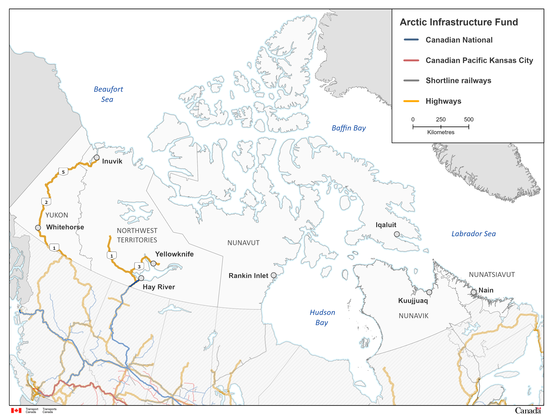
Text description of the map
Map of northern Canada showing transportation networks eligible under the Arctic Infrastructure Fund. The map highlights major rail lines, Canadian National (blue), Canadian Pacific Kansas City (red), and shortline railways (grey), as well as highways (orange). It depicts the Yukon, Northwest Territories, Nunavut, and northern regions of Quebec and Labrador, with key communities labeled including Whitehorse, Inuvik, Yellowknife, Hay River, Rankin Inlet, Iqaluit, Kuujjuaq, and Nain. Surrounding bodies of water such as the Beaufort Sea, Baffin Bay, Hudson Bay, and Labrador Sea are also shown. The legend in the upper right explains the colour coding, and the map uses a scale bar for distance.
Contact us
If you have questions about this program, contact us by email.
Email: TC.ArcticInfrastructureFund-FondsInfrastructureArctique.TC@tc.gc.ca
Related services and information
- Arctic Infrastructure Fund Applicant guide
- Arctic Infrastructure Fund Applicant Portal (Streams 1 and 2)
- Government of Canada announces investments totalling $6 billion to strengthen Canada’s trade and transportation infrastructure
- Government of Canada launches calls for proposals for the $5 billion Trade Diversification Corridors Fund and the $1 billion Arctic Infrastructure Fund
- Budget 2025