By Anthony MacKay, Director, Operational Safety, NAV CANADA
When I started flying in 1986, the definition pertaining to precision and non-precision approaches was very simple. Precision was ILS and everything else was non-precision where dive and drive was the way you managed the vertical. Today, with the advent of RNAV, the precision/non-precision line is very blurry. Let us consider the following approaches:
Conventional Approaches
- ILS
- LOC
- NDB
- VOR
RNAV Approaches
- LPV
- RNP
- L/V
- LNAV/VNAV
- LP
- LNAV
Now let’s list them by their ability to provide electronic vertical guidance and pilot derived vertical guidance via vertical speed or flight path angle:
Approaches with vertical guidance
- ILS
- LPV
- RNP
- L/V
- LNAV/VNAV
Approaches without vertical guidance
- LOC
- NDB
- VOR
- LP
- LNAV*
*may have advisory BARO VNAV
The approaches with vertical guidance can be further broken down to those that provide geometric vertical guidance and those that provide barometric vertical guidance:
Geometric vertical guidance
- ILS
- LPV
- L/V
Barometric vertical guidance
- RNP
- LNAV/VNAV
- LNAV*
*if advisory BARO VNAV is used
Geometric vertical guidance maintains a constant angle relative to the runway regardless of altimeter errors due to non-ISA temperatures, mountain wave effect or altimeter setting errors. As an example, during the winter at -35°C when flying the ILS or LPV to runway 12 in Edmonton, the aircraft, when on the glide path, will cross the FAF at the correct true altitude, but the indicated altitude will be higher than normal. During the summer at 35°C when flying the ILS or LPV to runway 12 in Edmonton, the aircraft, when on the glide path, will cross the FAF at the correct true altitude, but the indicated altitude will be lower than normal. If temperature corrections have been completed, this will be expected.
ILS 12
RNAV 12 (LPV)
|
ISA FAF Altitude and |
Indicated Altitude -35°C & Approach Angle |
Indicated Altitude 35°C & |
|---|---|---|
|
ILS 3650’ & 3° |
3893’ & 3° |
3548’ & 3° |
|
LPV 3600’ & 3° |
3833’ & 3° |
3502’ & 3° |
|
L/VFootnote 1 3600’ & 3° |
3833’ & 3° |
3502’ & 3° |
Barometric vertical guidance will shallow (cold) or steepen (warm) the approach angle relative to the runway due to altimeter errors like non-ISA temperatures, mountain wave effect or altimeter setting errors. As an example, during the winter at -35°C when flying the LNAV/VNAV or LNAV (*with advisory BARO VNAV) to runway 12 in Edmonton, the aircraft, when on the barometric vertical path, will cross the FAF at the correct indicated altitude, but the true altitude will be lower than designed. During the summer at 35°C when flying the LNAV/VNAV or LNAV (*with Advisory BARO VNAV) to runway 12 in Edmonton, the aircraft, when on the barometric vertical path, will cross the FAF at the correct indicated altitude, but the true altitude will be higher than designed. RNP procedures use barometric vertical paths and are subject to the same errors. The examples below show the effect without temperature compensation applied.
RNAV 12 (LNAV/VNAV or LNAV (*with advisory BARO VNAV)
|
ISA FAF indicated altitude and approach angle |
True altitude -35°C & approach angle |
True altitude 35°C & |
|---|---|---|
|
LNAV/VNAV 3600’ & 3° |
3367’ & 2.5° |
3698’ & 3.2° |
|
LNAVFootnote * 3600’ & 3° |
3367’ & 2.5° |
3698’ & 3.2° |
The good news is that if your flight management system (FMS) has a temperature compensation function, and you use it, the FMS will correct the aircraft vertical path for non-standard temperatures back to the correct true altitude and approach angle. Currently, aircraft procedures are developed for temperature compensation and cold temperatures, but very little guidance exists regarding higher than ISA temperatures on approach. For aircraft operators using FMS that do not have temperature compensation, cold temperature limits are included on the approach plate limiting the use of the approach to temperatures warmer than the published limit.
Additional good news is that Transport Canada is requiring that all new aircraft with FMS BARO VNAV have temperature compensation. “New or updated FMS designs shall provide a means for an aircraft to fly the true vertical path angle for final approach segment, as defined in the resident navigation database, in below ISA temperature conditions.” Transport Canada AC 500-020 provides additional information.
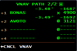
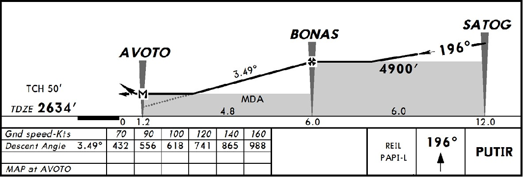
If you are flying a BARO VNAV path (RNP, LNAV/VNAV) with a FMS that does not use temperature compensation, you may expect the following PAPI indications when entering the visual segment of the approach. An additional caution must be observed when flying LNAV *with advisory BARO VNAV. The advisory BARO VNAV is derived from the runway threshold altitude +50 ft and projected back up the approach slope at 3° or the steeper angle required to provide a descent path above all step-down altitudes in the final approach segment. This provides the aircraft with a path to follow in the instrument segment of the approach that will clear all step-down altitudes and obstacles to LNAV minimums. The visual segment of the non-precision approach may require a different descent angle based on the PAPI. Dease Lake, BC, is a good example of this. The FMS has generated a path of 3.49° from BONAS to AVOTO to RWY20.
The CAP plate shows no vertical information.
The Jeppesen Plate shows 3.49° which matches the FMS coding.
But to clear obstacles in the visual segment of the approach to RWY 20 in Dease Lake, you have to fly the 4.0° PAPI in the visual segment of the approach.
If an LNAV procedure is collocated with an ILS, LPV, RNP or LNAV/VNAV procedure, the visual segment of the approach will be protected on the BARO VNAV path. If the LNAV procedure is stand-alone such as the Dease Lake example, the PAPI will provide the visual segment obstacle protection.
Finally, if using an SCDA technique (VS or FPA) on LP, LNAV, LOC, NDB or VOR procedures, the requirements of Transport Canada AC 700-028 must be adhered to.


