by NAV CANADA
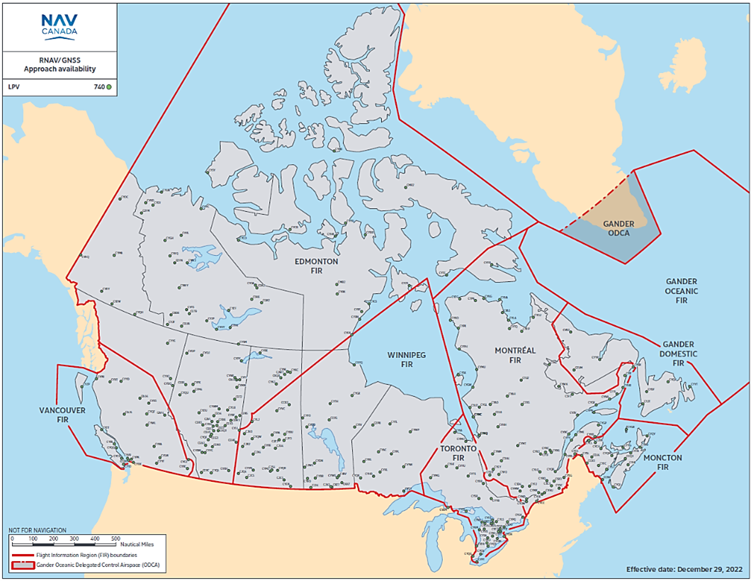
Approach procedures that offer localizer performance with vertical guidance (LPV) minima are found at many airports across Canada. As of December 2022, NAV CANADA has published 740 approaches that offer LPV minima.
LPV service has proven to be quite robust and reliable in many parts of the country. Temporary losses of service typically occur only a very small fraction of the time, but NAV CANADA does occasionally receive pilot reports describing a loss of service while carrying out these approach procedures. (Note: This article focuses on LPV, although localizer performance [LP] and WAAS-based lateral navigation/vertical navigation [LNAV/VNAV] can be similarly affected.)
To take advantage of LPV, aircraft need to rely on a satellite-based augmentation system (SBAS) to augment the position that was calculated using a global navigation satellite system (GNSS) core constellation. In Canada, we are lucky enough to have access to the Federal Aviation Administration (FAA) SBAS, which has been named wide area augmentation system (WAAS). SBAS signals are transmitted to WAAS-capable onboard receivers from three geostationary Earth orbit (GEO) satellites located overhead of the equator at 117°, 125° and 129° west, essentially putting them somewhat south of California. In 2022, the FAA completed a multi-year lifecycle replacement, and the new WAAS GEOs are now slightly further west than they used to be. This guarantees the U.S. triple-redundant WAAS coverage from Maine all the way to the western edge of Alaska, but it means that aircraft operating in eastern Canada might now see WAAS GEOs a bit lower on the horizon than they used to, and in some locations receivers may not see as many GEOs as they once did. Here are the three new WAAS GEO satellite footprints:
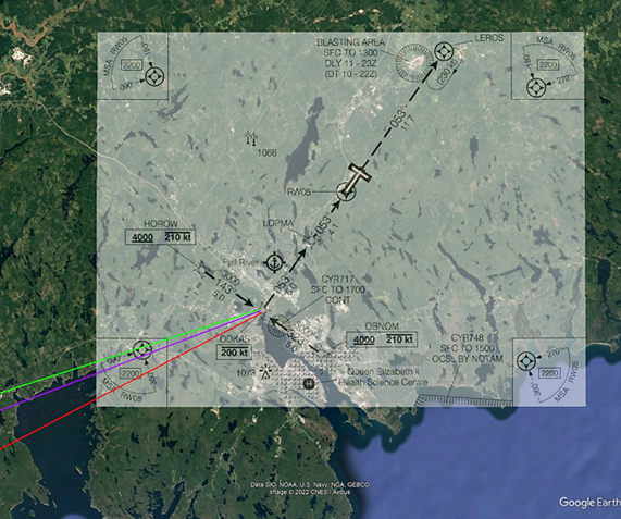
When all three WAAS GEOs are operating normally, WAAS-capable receivers inside the green line should be able to see all three satellites; although the closer you get to that green line, the lower on the horizon those GEOs will appear. Between the green and purple lines, receivers might only be able to see two of the GEOs, and between the purple and red lines, only one GEO might be receivable. Figure 2 notations have historically been made on instrument approach procedure charts that were found to have reduced service near the fringe of WAAS coverage, but given the new WAAS GEO locations, NAV CANADA plans to begin adding the following note to any WAAS procedure that now falls outside of the green line: “Procedure on the fringe of WAAS coverage. Occasional outages may occur.”
Let’s say we are flying inside the green line near Halifax, trying to receive messages from one of the WAAS GEOs. This is where we could imagine the three GEOs might be located in relation to the horizon (Figure 3).
WAAS-capable receivers are designed to receive messages from as little as one GEO, including GEOs that are relatively low on the horizon like in our Halifax example, but sometimes non-ideal conditions can make it more challenging. One of those conditions is space weather.
The source of space weather is the sun, which can release streams of charged particles that could affect LPV service. LPV requires accurate ionospheric corrections, as well as relatively narrow integrity bounds, and these bounds may be widened during periods when the ionosphere is severely disturbed by these charged particles. In other words, during space weather events, the system is designed to trigger an integrity alert much earlier than a WAAS-capable receiver normally would; that’s how it keeps you safe. Occasional interruptions of LPV service can occur during severe geomagnetic storms and affect portions of the service area for short periods of time. In rare cases, extremely severe geomagnetic storms may even cause temporary loss of LPV service over large portions of the WAAS service area for several hours. (Note: space weather has historically had very limited effect on non-WAAS procedures such as LNAV, and in most cases NAV CANADA tries to publish an LNAV line of minima for each runway where a WAAS-based approach has been published.)
During pre-flight planning, pilots can consult the Canadian Space Weather Forecast Centre products to determine if LPV service for their flight could be affected.
When space weather is forecast to be moderate or severe, space weather advisories (SWX ADVISORY) are promulgated under the significant meteorological information (SIGMET) service, like volcanic ash advisories would be. This is not something that happens every day, but is still something that pilots should be aware of. See the Transport Canada Aeronautical Information Manual (TC AIM) sections COM 5.5.4 and MET 14.0 for additional details.
Back to our Halifax example: another challenge we could suffer from is WAAS signals that get blocked by aircraft structures, particularly the wings during banked attitudes as well as the empennage when the GEOs might be directly aft of the aircraft. Of course, different airframe configurations as well as antenna mounting locations can result in variation in signal reception. Let’s imagine we were flying the RNAV (GNSS) Z approach to runway 05 and turning from one of the initial approach segments onto the intermediate approach segment at the ODKAS waypoint, where we would join the extended runway centreline. Here it is overlayed on Google Earth, including the direction where we might see the three WAAS GEO signals coming from (Figure 4).
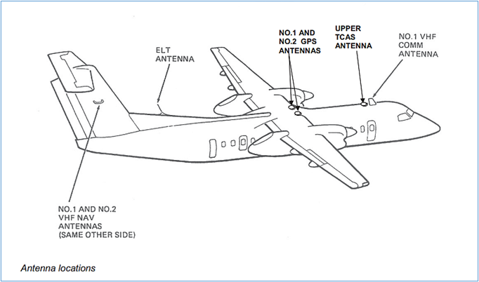
Now let’s imagine that we were flying an aircraft such as this, with GPS (WAAS) antennas installed near the wings (Figure 5).
An aircraft like this with a high-wing configuration could present the pilot an integrity warning, or a loss of LPV capability, as the aircraft enters a banked attitude at ODKAS. Outside of the final approach segment, temporary losses of the WAAS signal are allowed by the receiver and, for some aircraft, once the signal is regained the receiver might be able to continue the LPV. Other aircraft may be able to downgrade the level of service from LPV, and fly to the unaffected LNAV minima. Some aircraft may need to execute the missed approach. (Note: If loss of the WAAS signal for more than a few seconds occurs during the final segment of the approach, the guidance will be flagged and a missed approach will likely result; at this point in the approach any flag that gets displayed is latched, and it will not be possible to resume the approach even if the WAAS signal is subsequently reacquired.) Once the aircraft has completed the turn at ODKAS and is established inbound on the intermediate segment, a large empennage could continue to cause problems by blocking the WAAS signal. Airframe design and antenna location combined with low WAAS GEO elevation angles can be challenging.
To be able to track losses of LPV events, pilots are always encouraged to report observations to air traffic services, regardless of if there is any note on the approach chart or not. The more details provided, especially if it happens to only be a partial loss such as “loss of LPV vertical guidance,” along with the exact location where the loss occurred, will continue to help NAV CANADA determine if changes to the design of the approach procedure are required to reduce the number of events.
Despite the occasional challenge, LPV procedures continue to markedly increase airport accessibility and offer pilots and aircraft operators a safe way to carry out vertically guided approaches to many runways in Canada. If you have more questions about WAAS or LPV, feel free to send them to service@navcanada.ca and we will do our best to answer.


