
First Edition
December 2005
Copyright
© Her Majesty the Queen in Right of Canada, represented by the Minister of Transport, 2005.
Cette publication est aussi disponible en français sous le titre Spécimen d’examen - Permis de pilote - avion ultra-léger.
For a print copy or an accessible version of this publication, please visit http://transact-en.tc.gc.ca or contact Transport Canada’s Publications Order Desk at 1-888-830-4911 — International at 613-991-4071.
An electronic version of this publication is available at https://tc.canada.ca/en/aviation/publications/sample-examination-pilot-permit-ultra-light-aeroplane-tp-14454
TP 14454E
(04/2009)
TC-1003182
Catalogue No. T52-4/32-1-2009E
ISBN 978-1-100-12736-1
Permission to reproduce
Transport Canada grants permission to copy and/or reproduce the contents of this publication for personal and public noncommercial use. Users must reproduce the materials accurately, identify Transport Canada as the source and not present theirs as an official version, or as having been produced with the help or the endorsement of Transport Canada.
To request permission to reproduce materials from this publication for commercial purposes, contact:
Publishing and Depository Services
Public Works and Government Services Canada
Ottawa ON K1A 0S5
droitdauteur.copyright@tpsgc-pwgsc.gc.ca
Foreword
This sample examination has been developed by Transport Canada to assist candidates prepare for the Ultra-light Pilot Permit written examinations.
The questions contained in the sample examination are selected to indicate the form and type of questions that will be encountered.
The Ultra-light Pilot Permit examination consists of 80 questions, with a pass mark of 60%; the time permitted is 3 hours.
Candidates are referred to the Study and Reference Guide titled Pilot Permit - Ultra-light Aeroplane (TP 14453E) which specifies the subject areas from which questions may be set.
Abbreviations
Note: The abbreviations and acronyms listed below may be used throughout this sample examination.
- AGL
- above ground level
- ASL
- above sea level
- ATC
- Air Traffic Control
- ATF
- Air Traffic Frequency
- ATIS
- Automatic Terminal Information Service
- ATS
- Air Traffic Services
- CAME
- Civil Aviation Medical Examiner
- CARs
- Canadian Aviation Regulations
- C of A
- Certificate of Airworthiness
- CG
- Centre of Gravity
- CFS
- Canada Flight Supplement
- cm.
- centimetre
- ELT
- emergency locator transmitter
- ETA
- estimated time of arrival
- FSS
- Flight Service Station
- ft.
- feet
- gal.
- gallon
- GFA
- graphic area forecast
- gph
- gallon(s) per hour
- ICAO
- International Civil Aviation Organization
- IFR
- instrument flight rules
- in.
- inches
- kg
- kilogram
- KT
- knot
- lb
- pound
- M
- magnetic
- MHz
- megahertz
- NM
- nautical mile
- NORDO
- no radio
- NOTAM
- notice to airmen
- SPP
- Student Pilot Permit
- SVFR
- special visual flight rules
- TC A.I.M.
- Aeronautical Information Manual
- TSB
- Transportation Safety Board of Canada
- UNICOM
- universal communications
- VFR
- visual flight rules
Questions
1. Following the use of alcohol or drugs, no person shall act as a flight crew member
- (1) for 12 hours.
- (2) for 24 hours.
- (3) for 48 hours.
- (4) if their ability is impaired.
2. Flying with a cold
- (1) is always safe while taking antihistamine tablets.
- (2) will help clear the sinuses.
- (3) is safe below 5,000 ft.
- (4) can cause a prolonged infection of the middle ear.
3. When an ultra-light aeroplane is used to tow an object, it must be equipped with a tow hook
- (1) of any type.
- (2) provided by the aircraft company.
- (3) containing alluminum alloys.
- (4) and a release control system.
4. Explosives or other dangerous articles shall not be carried on board any aircraft
- (1) unless in compliance with the Transportation of Dangerous Goods Act.
- (2) unless the appropriate ATC unit is advised.
- (3) in which passengers are carried.
- (4) except weapons or ammunition required for warfare.
5. No person shall fly or attempt to fly as a flight crew member of an aircraft if that person
- (1) is less than 18 years of age.
- (2) has consumed alcohol or drugs within the 72 hour period prior to take-off.
- (3) is aware of being under any physical disability that might render that person unable to meet the requirements for the issue or renewal of their licence or permit.
- (4) is over 60 years of age.
6. Any person holding a licence, permit or certificate issued under the authority of the CARs shall produce such document for inspection, upon demand by
- (1) an airport owner or operator.
- (2) any pilot holding a senior licence.
- (3) a peace officer, or immigration officer.
- (4) a pilot holding a valid instructor rating.
7. The CARs stipulate that.....must be worn by pilots when operating basic ultra-light aeroplanes.
- (1) boots
- (2) gloves
- (3) goggles
- (4) helmets
8. Effective collision avoidance scanning technique requires
- (1) a series of regularly spaced eye movements focusing for at least one second on each block area.
- (2) a continuous sweeping motion scanning back and forth along the horizon.
- (3) concentrating on a distant object to prevent the eyes from focusing nearby on an empty field of vision.
- (4) an up and down sweeping motion cutting the horizon at a 30° angle.
9. Applicants for the Pilot Permit - Ultra-Light Aeroplane shall be at least.....years old.
- (1) 14
- (2) 16
- (3) 17
- (4) 18
10. 'Day' in Canada is defined as that period of time between
- (1) sunrise and sunset.
- (2) one hour before sunrise and one hour after sunset.
- (3) the end of morning civil twilight and the beginning of evening civil twilight.
- (4) the beginning of morning civil twilight and the end of evening civil twilight.
11. Designated airspace of defined dimensions surrounding an operating control tower at an airport is known as a(n)
- (1) terminal control area.
- (2) control zone.
- (3) control area.
- (4) aerodrome traffic zone.
12. Except for the purpose of taking off or landing, an aircraft shall not be flown over an aerodrome at a height of less than.....ft AGL.
- (1) 2,000
- (2) 1,500
- (3) 1,000
- (4) 500
13. Unless otherwise specified, all turns in the circuit at an aerodrome shall be made to the
- (1) left.
- (2) right.
- (3) left, except when joining the cross-wind leg.
- (4) right, except when joining the cross-wind leg.
14. An ultra-light aeroplane may be operated within a control zone, when the ATC unit is not operating, if permission has been received from the
- (1) tower.
- (2) FSS.
- (3) airport operator.
- (4) flying school.
15. Basic ultra-light aeroplanes shall be flown
- (1) clear of designated airways.
- (2) clear of terminal control areas.
- (3) with visual reference to the ground or water.
- (4) all of the above.
16. A pilot on a VFR flight within controlled airspace, must remain clear of cloud by at least.....ft vertically and..... mile(s) horizontally.
- (1) 500, 1
- (2) 500, 3
- (3) 1,000, 1
- (4) 1,000, 3
17. With the operation of ultra-light aeroplanes in active Class F airspace identified as CYA,
- (1) flight activity may be conducted only under IFR.
- (2) a VFR flight requires permission before entry.
- (3) pilots of non-participating flights must not enter.
- (4) participating and non-participating pilots are equally responsible for collision avoidance.
18. The daytime closed markings for any part of the manoeuvring area of an airport is a
- (1) red and white checkered flag.
- (2) horizontal white landing 'T'.
- (3) white or yellow 'X'.
- (4) white dumb-bell.
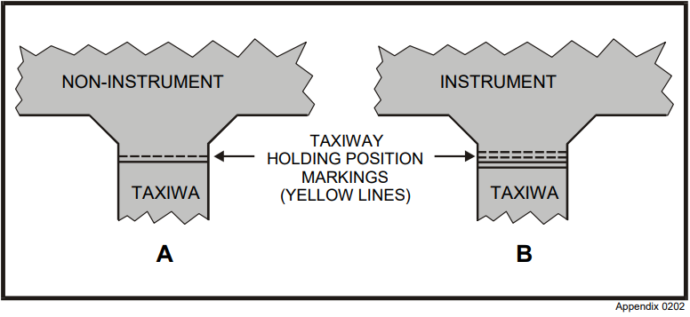
19. Refer to the Appendix: Holding position markings (Diagram #1).
At controlled airports, the taxiway markings in diagrams A and B indicate that aircraft must stop before crossing
- (1) the lines from either side at all times.
- (2) the lines from either side unless otherwise cleared by ATC.
- (3) from the solid line side at all times.
- (4) from the solid line side unless otherwise cleared by ATC.
20. If a flight itinerary contains a search and rescue (SAR) action initiation time, pilots shall report their arrival to the responsible person
- (1) not later than the SAR initiation time specified in the flight itinerary.
- (2) 24 hours after the last reported ETA.
- (3) 36 hours after the last reported ETA.
- (4) one hour after the ETA.
21. After accepting a clearance and subsequently finding that it cannot be complied with, a pilot should
- (1) take any immediate action required and advise ATC as soon as possible.
- (2) comply as best as possible under the circumstances and say nothing to ATC.
- (3) disregard the clearance.
- (4) comply with the suitable parts.
22. If the aircraft's heading is 270° when ATC states, "Traffic 9 o'clock, 5 miles, eastbound", the traffic would be
- (1) 60° to the right at the same altitude.
- (2) 90° to the right on a collision course.
- (3) 90° to the left, altitude unknown.
- (4) on a heading of 80°.
23. At the request of the pilot, VHF direction finding stations normally provide a homing service
- (1) on a pre-selected tower or FSS frequency.
- (2) only in Class B airspace.
- (3) only after declaration of an emergency on 121.5 MHz.
- (4) on the approach control frequency.
24. What determines the angle of attack at which a particular aeroplane stalls?
- (1) Gross weight.
- (2) Centre of Gravity.
- (3) Design of the wing.
- (4) Load factor.
25. If the wing of a trike has more than one hang point and a change is made from an aft to a forward hang point, the
- (1) trim speed will decrease.
- (2) trim speed will increase.
- (3) airspeed will increase.
- (4) airspeed will decrease.
26. At the stall from a co-ordinated climbing turn to the left, the..... wing will stall first and the aircraft will roll to the.....
- (1) right, left.
- (2) right, right.
- (3) left, left.
- (4) left, right.
27. The rule that maximum gross weight shall not be exceeded and the CG shall remain within the permissible range for every flight, is
- (1) applicable only when passengers are carried.
- (2) applicable to all aircraft.
- (3) not applicable to twin-engine aircraft.
- (4) not applicable to ultra-light aircraft.
28. The standard empty weight of an aircraft
- (1) includes the unusable fuel and oil.
- (2) does not change for aircraft of the same type.
- (3) includes the weight of the occupants.
- (4) shall be calculated annually.
29. An ultra-light aeroplane with a maximum permissible gross weight of 330 kg has CG limits of 20.0 to 26.0 cm from the datum. The aeroplane is loaded as follows:
| Item | Weight (kg) | Moment Arm (cm) | Moment (cm-kg) |
|---|---|---|---|
| Empty weight | 160 | +60 | ? |
| Instructor | 85 | 0 | ? |
| Student | 60 | -70 | ? |
| Fuel and oil | 20 | +40 | ? |
Calculations based on the above data indicate that the maximum gross weight is
- (1) not exceeded, and the CG is within limits.
- (2) not exceeded, but the CG is too far forward.
- (3) not exceeded, but the CG is too far aft.
- (4) exceeded, but the CG is within limits.
30. The forecast surface wind will be included in a GFA if it has a sustained speed of at least.....kt.
- (1) 5
- (2) 10
- (3) 15
- (4) 20
31. With the passage of a cold front, the surface wind will usually
- (1) veer and increase in speed.
- (2) back and decrease in speed.
- (3) increase in speed without a change in direction.
- (4) change direction without a change in speed.
32. Failure to adjust the altimeter when flying from an area of low pressure to an area of higher pressure will result in the aircraft indicated altitude reading
- (1) higher than the actual altitude.
- (2) lower than the actual altitude.
- (3) the actual true altitude.
- (4) the actual pressure altitude.
33. An ultra-light aeroplane flying in a strong head wind on approach suddenly encounters a no wind condition near the ground. The immediate effect of this wind shear will be
- (1) a decrease in the rate of sink.
- (2) an increase in indicated airspeed.
- (3) an increase in the true airspeed.
- (4) an increase in the rate of sink.
34. In which case should the smoothest flight be expected?
- (1) Under an overcast of stratus cloud.
- (2) On a clear hot summer day when there is no cloud.
- (3) Under scattered cumulus cloud.
- (4) Under a layer of stratocumulus cloud.
35. Turbulence near the ground due to surface heating will usually be most severe
- (1) immediately after sundown.
- (2) during the early morning hours after sunrise.
- (3) about mid-morning.
- (4) during the early afternoon.
36. When steady rain is encountered in flight, it can cause
- (1) dissipation of pollution which decreases visibility.
- (2) low stratus or fog to form below the aircraft.
- (3) frequent and moderate turbulence.
- (4) treacherous down currents.
37. The amount of water vapour that a given volume of air can contain is governed by its
- (1) relative humidity.
- (2) density.
- (3) temperature.
- (4) dewpoint.
38. The part of a frontal system along which cold air is retreating is called
- (1) a warm front.
- (2) a cold front.
- (3) a quasistationary front.
- (4) an occluded front.
39. Thunder and lightning are associated with..... clouds.
- (1) castellanus
- (2) altostratus
- (3) cumulonimbus
- (4) stratus
40. When confronted with a thunderstorm, take-off or landing
- (1) should be avoided as a sudden wind shift or low level turbulence could cause a loss of control.
- (2) should be avoided unless ATC tells you to take-off or land.
- (3) is safe if you can see under the thunderstorm to the other side.
- (4) is safe if the thunderstorm is regarded as light.
41. Relative humidity is the
- (1) amount of moisture present in the air.
- (2) weight of water present in the air.
- (3) amount of moisture present in the air compared to the amount the air could hold at that temperature and pressure.
- (4) temperature to which you must lower the air temperature to bring about saturation.
42. Advection fog forms when
- (1) moist air moves from a warm surface to a colder surface.
- (2) the cold ground cools the air in contact with it at night.
- (3) moist air is influenced by orographic effect.
- (4) moist cool air moves from a cold surface to a warm surface.
43. Which cloud type indicates the presence of significant vertical currents at low levels?
- (1) Stratus Fractus.
- (2) Altocumulus.
- (3) Cumulus.
- (4) Nimbostratus.
44. If ice has accumulated on an aerofoil in flight, the stalling speed will
- (1) remain unchanged.
- (2) decrease in all flight conditions.
- (3) increase in level flight only.
- (4) increase in all flight conditions.
45. Accelerating in an easterly direction you would see the magnetic compass
- (1) indicate a turn towards north.
- (2) indicate a turn towards south.
- (3) always remain within 5º of the heading.
- (4) remain steady.
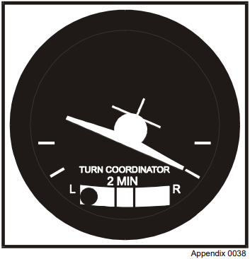
46. Refer to the Appendix: Turn co-ordinator (Diagram #1).
The turn co-ordinator indicates that the aircraft is in a
- (1) slipping left turn.
- (2) skidding left turn.
- (3) slipping right turn.
- (4) skidding right turn.
47. What are the strokes of a four stroke engine called?
- (1) Ignition, compression, fuel, exhaust.
- (2) Ignition, cooling, oil, exhaust gas temperature.
- (3) Intake, compression, power, exhaust.
- (4) Intake, cooling, thrust, exhaust.
48. Unlike the two stroke engine, the four stroke engine
- (1) is more tolerant of problems as they develop.
- (2) is lighter in weight and smaller in size.
- (3) is completely pressurized.
- (4) has no tolerance for anything not set perfectly.
49. The exhaust gas temperature (EGT) guage gives you a direct indication of the
- (1) cylinder head temperature.
- (2) engine coolant.
- (3) oil.
- (4) air-fuel mixture setting.
50. The viscosity of the oil to be used in an aircraft engine is specified by the manufacturer and can be identified by the
- (1) SAE number.
- (2) octane rating.
- (3) specific gravity.
- (4) standard colour code.
51. A propeller that is balanced
- (1) detects oil pressure.
- (2) provides equal thrust to the engine.
- (3) prevents yaw in the climb.
- (4) prevents strong vibrations.
52. Two advanced ultra-light aeroplanes have fixed pitch propellers. The propeller on 'A' has a fine (high rpm) pitch compared to the propeller on 'B' which has a coarse (low rpm). Ultra-light aeroplane
- (1) 'A' will have the better take-off and climb performance but poorer cruise performance.
- (2) 'B' will have the better take-off and climb performance but poorer cruise performance.
- (3) 'A' will have the better take-off and cruise performance but poorer climb performance.
- (4) 'B' will have the better take-off and cruise performance but poorer climb performance.
53. Which instrument will not work properly if the pitot pressure source and its drain vents become blocked?
- (1) Altimeter.
- (2) Airspeed indicator.
- (3) Vertical speed indicator.
- (4) Attitude indicator.
54. When a parked aircraft's altimeter is set to the local setting, it would indicate the
- (1) pressure altitude of the airport.
- (2) absolute altitude of the airport.
- (3) airport altitude above sea level.
- (4) airport density altitude above sea level.
55. The movement of an aircraft about the longitudinal axis is known as
- (1) yaw.
- (2) roll.
- (3) pitch.
- (4) a couple.
56. If the elevator trim control is set full nose-up, the trim tab on the elevator should be
- (1) between neutral and full up.
- (2) neutral.
- (3) full up.
- (4) full down.
57. The most important feature affecting directional stability is
- (1) the fin and rudder.
- (2) sweepback.
- (3) keel effect.
- (4) rudder trim.
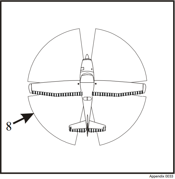
58. Refer to the Appendix: Taxiing Diagram #8.
The diagram shows the plan view of a tricycle gear ultra-light aircraft taxiing in a wind from the 8 o'clock direction at 15 kt. The recommended position for the left aileron is
- (1) down.
- (2) up.
- (3) neutral.
- (4) position has no effect.
59. If a strong crosswind from your left is present during take-off, you should leave the ground at
- (1) a higher than normal speed.
- (2) a lower than normal speed.
- (3) an increased flap setting.
- (4) normal speed.
60. An ultra-light aeroplane and a glider are both approaching to land. The glider has the right-of-way because
- (1) it is slower.
- (2) it has less ability to manoeuvre.
- (3) of the wake turbulence created by the aeroplane.
- (4) of a closer circuit pattern for gliders.
61. You observe another ultra-light aeroplane on the horizon ahead. A collision could occur if it appears to
- (1) remain stationary and increases in size.
- (2) remain stationary and decreases in size.
- (3) move across the horizon, but remains the same size.
- (4) move across the horizon, and decreases in size.
62. When two aircraft are approaching head-on or approximately so and there is danger of collision, each pilot shall
- (1) alter heading to the right.
- (2) alter heading to the left.
- (3) avoid the other by changing altitude.
- (4) turn on the anti-collision lights.
63. If you experience an engine failure immediately after take-off
- (1) conduct a 20 degree bank turn back to the runway.
- (2) conduct the steepest bank turn possible back to the runway.
- (3) land straight ahead.
- (4) maintain climb pitch attitude and attempt a restart.
64. When turning from downwind to into-wind at low altitude, a pilot may experience an illusion of
- (1) slipping and decreasing airspeed.
- (2) skidding and decreasing airspeed.
- (3) slipping and increasing airspeed.
- (4) skidding and increasing airspeed.
65. If there is rain falling on your windshield during an approach, the terrain contours will appear..... than they actually are to you.
- (1) no differently
- (2) closer
- (3) higher
- (4) lower
66.Ultra-light aircraft behind heavier aircraft on final approach should remain
- (1) below the approach path of the heavier aircraft.
- (2) above the approach path of the heavier aircraft.
- (3) on the same approach path but at a higher speed.
- (4) on the same approach path but at a slower speed.
67. What should a pilot broadcast to indicate serious or imminent danger, and to request immediate assistance?
- (1) mayday, mayday, mayday.
- (2) pan pan, pan pan, pan pan.
- (3) security, security, security.
- (4) emergency, emergency, emergency.
68. One of the factors that may lead to wheelbarrowing on landing is
- (1) a shallow approach angle.
- (2) a high round out.
- (3) excessive speed on approach in the full flap configuration.
- (4) a low approach speed in the full flap configuration.
69. When an aircraft engine is left running on the ground and no person remains onboard, the aircraft's movement must be restricted and
- (1) it must remain in sight of the pilot at all times.
- (2) it must not be left unattended.
- (3) its gross weight must be below 1200 lb.
- (4) its control locks must be installed.
70. If an aircraft accident occurs, the pilot or operator of that aircraft shall ensure that it is reported to the TSB
- (1) within 7 days.
- (2) within 48 hours.
- (3) within 24 hours.
- (4) as soon as possible thereafter, using the quickest means of communication.
71. An aircraft should be properly grounded when refuelling, to prevent
- (1) spillage.
- (2) a pump failure.
- (3) static discharge.
- (4) fuel vapors.
72. A single-engine aircraft operating beyond gliding distance from shore or taking off from or landing on water shall have on board
- (1) one life jacket for each person.
- (2) a water activated ELT.
- (3) a life raft of sufficient size to accommodate all persons.
- (4) all of the above plus emergency equipment specified in CARs.
73.
| Average fuel consumption | 5 gph |
|---|---|
| Total flight time | 30 minutes |
Note: Add 2 gallons for taxi, take-off and climb.
Using the above information calculate the fuel requirement for your trip.
- (1) 10 gal.
- (2) 7 gal.
- (3) 4.5 gal.
- (4) 4 gal.
74. One minute of latitude is equal to
- (1) one minute of longitude.
- (2) one statue mile.
- (3) one nautical mile.
- (4) 5,000 feet.
75. If a heading of 250°M maintains your outbound track of 242°M, the heading most likely for your reciprocal track for your return would be
- (1) 078°M.
- (2) 070°M.
- (3) 062°M.
- (4) 054°M.
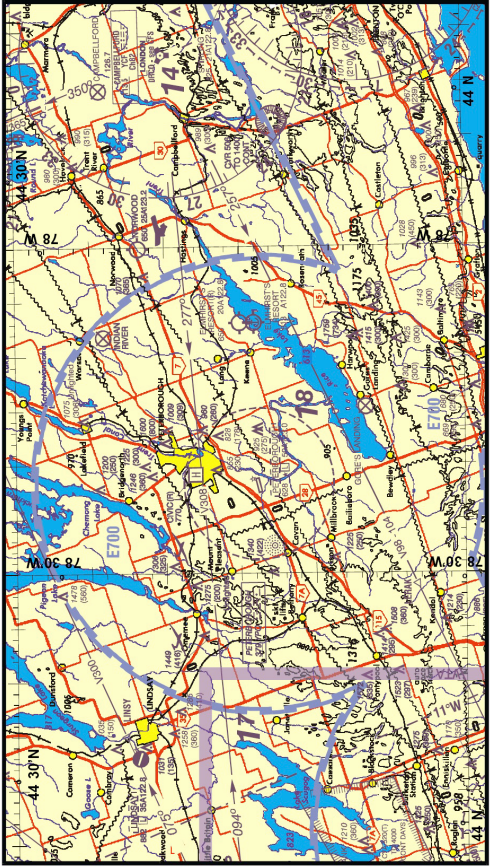
For questions 76 to 80 inclusive, refer to the Appendix 'Cross Country Flight' and the VNC chart.
76. Refer to the VNC.
The large bold number "18", southeast of the Peterborough airport represents the..... for the given quadrangle.
- (1) highest terrain
- (2) highest terrain plus 328 ft or the highest known obstruction, whichever is higher
- (3) minimum reception altitude
- (4) minimum obstacle clearance
77. Refer to the VNC.
The hypsometric tinting on the chart indicates that between the Lindsay and Norwood airports the flight will be conducted over a ground elevation between
- (1) sea level and 1,000 ft.
- (2) sea level and 1,500 ft.
- (3) 1,000 ft and 2,000 ft.
- (4) sea level and 2,000 ft.
78. Refer to the VNC.
The highest obstacle within 5 NM either side of your track from Lindsay to Norwood is..... ft ASL.
- (1) 1,600
- (2) 1,449
- (3) 1,275
- (4) 1,246
79. Refer to the VNC.
The dashed circle around Peterborough represents a(n)
- (1) advisory area.
- (2) terminal control area.
- (3) control zone.
- (4) prohibited area.
80. Refer to the VNC. Approaching Norwood, you decide to get the latest weather for Kingston. What would be the most appropriate station and frequency to call?
- (1) Peterborough UNICOM 122.8 MHz.
- (2) London 126.7 MHz.
- (3) Campbellford Radio 113.5 MHz.
- (4) Trenton Tower 128.7 MHz.
Appendix
Holding Position Markings (Diagram #1)
Turn Coordinator (Diagram #1)
Taxiing Diagram #8
Cross Country Flight
Chart:
The chart to be used with this examination is the partial Toronto VFR Navigation Chart supplied in this Appendix.
Flight Planning Details:
The cross-country is a day VFR flight from the Lindsay aerodrome (CNF4) to the Peterborough airport (CYPQ) to the Norwood aerodrome (CPY4)
The centre of the aerodrome symbols should be used as measuring points for each leg.
| Identifier | Aerodrome Name | Geographical Coordinates |
|---|---|---|
| CNF4 | Lindsay | N44° 22' W78° 47' |
| CYPQ | Peterborough | N44° 14' W78° 22' |
| CPY4 | Norwood | N44° 22' W78° 00' |
Partial Toronto VNC
(Not to be used for navigation)
Use any Canadian VNC Legend
Answer Key
| Question no. |
Answer | Question no. |
Answer | Question no. |
Answer | Question no. |
Answer |
|---|---|---|---|---|---|---|---|
|
1 |
(4) |
2 |
(4) |
3 |
(4) |
4 |
(1) |
|
5 |
(3) |
6 |
(3) |
7 |
(4) |
8 |
(1) |
|
9 |
(2) |
10 |
(4) |
11 |
(2) |
12 |
(1) |
|
13 |
(1) |
14 |
(3) |
15 |
(4) |
16 |
(1) |
|
17 |
(4) |
18 |
(3) |
19 |
(4) |
20 |
(1) |
|
21 |
(1) |
22 |
(3) |
23 |
(1) |
24 |
(3) |
|
25 |
(2) |
26 |
(2) |
27 |
(2) |
28 |
(1) |
|
29 |
(2) |
30 |
(4) |
31 |
(1) |
32 |
(2) |
|
33 |
(4) |
34 |
(1) |
35 |
(4) |
36 |
(2) |
|
37 |
(3) |
38 |
(1) |
39 |
(3) |
40 |
(1) |
|
41 |
(3) |
42 |
(1) |
43 |
(3) |
44 |
(4) |
|
45 |
(1) |
46 |
(4) |
47 |
(3) |
48 |
(1) |
|
49 |
(4) |
50 |
(1) |
51 |
(4) |
52 |
(1) |
|
53 |
(2) |
54 |
(3) |
55 |
(2) |
56 |
(4) |
|
57 |
(1) |
58 |
(1) |
59 |
(1) |
60 |
(2) |
|
61 |
(1) |
62 |
(1) |
63 |
(3) |
64 |
(2) |
|
65 |
(4) |
66 |
(2) |
67 |
(1) |
68 |
(3) |
|
69 |
(2) |
70 |
(4) |
71 |
(3) |
72 |
(1) |
|
73 |
(3) |
74 |
(3) |
75 |
(4) |
76 |
(2) |
|
77 |
(1) |
78 |
(1) |
79 |
(3) |
80 |
(2) |