
Subject: When to Submit an Aeronautical Assessment Form (AAF)
| Issuing Office: | Civil Aviation, Standards |
|---|---|
| Document No.: | AC 601-007 |
| File Classification No.: | Z 5000-34 |
| Issue No.: | 01 |
| RDIMS No.: | 16998670-V30 |
| Effective Date: | 2024-02-27 |
Table of contents
- 1.0 Introduction
- 2.0 References and requirements
- 3.0 Background
- 4.0 Notification for construction or alteration
- 5.0 Information management
- 6.0 Document history
- 7.0 Contact us
- Annex 1 – Example, Runway-type Aerodrome
- List of figures
- Figure 1 – OnS Overview
- Figure 2 – OnS-A for Certified Runway-type aerodromes and Registered Aerodromes with IAP
- Figure 3 – OnS-A for registered aerodromes without IAP
- Figure 4 – OnS-A for heliports
- Figure 5 – Catenary – transmission line
- Figure 6 – Water aerodrome without defined water channel
- Figure 7 – Windturbines and windfarms
- Figure 8 – Example - Runway-type aerodrome
1.0 Introduction
(1) This Advisory Circular (AC) is provided for information and guidance purposes. It describes an example of an acceptable means, but not the only means, of demonstrating compliance with regulations and standards. This AC on its own does not change, create, amend, or permit deviations from regulatory requirements, nor does it establish minimum standards.
1.1 Purpose
(1) The purpose of this AC is to provide guidance for when to submit an Aeronautical Assessment Form (AAF) for obstacle notification and assessment to the Minister.
1.2 Applicability
(1) This AC is applicable to any person who plans to construct or modify a building, structure or object, or launch a tethered object who would be notifying the Minister of their plan, using the AAF in accordance with Section 601.24 of the Canadian Aviation Regulations [CARs]. This AC is also applicable to Transport Canada Civil Aviation (TCCA) Headquarters and regional personnel and to the aviation industry in general.
1.3 Description of changes
(1) Not applicable.
2.0 References and requirements
2.1 Reference documents
(1) It is intended that the following reference materials be used in conjunction with this document:
- (a) Aeronautics Act (R.S.C., 1985, c. A-2)
- (b) Part VI, Subpart 01, Division III of the Canadian Aviation Regulations (CARs) — Marking and Lighting of Obstacles to Air Navigation, Obstacles to Air Navigation, Sections 601.23 to 601.25
- (c) Standard 621 of the CARs - Obstruction Marking and Lighting
- (d) Advisory circular (AC) 601-005 Meteorological Tower (MET) Notification
- (e) Aeronautical Assessment Form [AAF] for obstacle notification and assessment; Forms Catalog #26-0427
- (f) NAV CANADA – Canada Flight Supplement (CFS) — Canada and North Atlantic Terminal and Enroute Data
- (g) NAV CANADA – Canada Water Aerodrome Supplement (CWAS)
- (h) NAV CANADA – Canadian Airport Charts
2.2 Cancelled documents
(1) Not applicable.
(2) By default, it is understood that the publication of a new issue of a document automatically renders any earlier issues of the same document null and void.
2.3 Definitions and abbreviations
(1) The following abbreviations are used in this document:
- (a) AAF: Aeronautical Assessment Form
- (b) AGL: Above Ground Level
- (c) AMSL: Above Mean Sea Level
- (d) CAR: Canadian Aviation Regulations
- (e) CFS: Canada Flight Supplement
- (f) CWAS: Canada Water Aerodrome Supplement
- (g) FATO: Final Approach and Take Off area
- (h) IAP: Instrument Approach Procedure;
- (i) OnS: Object Notification Surface (basic)
- (j) OnS-A: Object Notification Surface (near an aviation facility)
- (k) TCCA: Transport Canada Civil Aviation.
3.0 Background
(1) Section 601.24 of the CARs requires any person who plans to construct or modify a building, structure, or object, or launch a tethered object to notify the Minister of the proposed construction, modification or launch in accordance with the requirements of Standard 621 if the building, structure or object, or tethered object, will constitute an obstacle to air navigation. Notification is by submittal of an Aeronautical Assessment Form (AAF) to the applicable Transport Canada Civil Aviation (TCCA) regional office.
(2) Whether a building, structure, or object will constitute an obstacle to air navigation is dependent upon Section 601.23 of the CARs and also upon Section 601.25 of the CARs. Section 601.23 of the CARs identifies objects that are certain to be obstacles to air navigation. Section 601.25 of the CARs is for objects other than those described in Section 601.23 of the CARs, that the Minister determines to be a hazard to air navigation.
(3) The proponent is, therefore, presented with a difficulty. With respect to Section 601.25 of the CARs, knowing that the object will be an obstacle is only possible after the Minister has reviewed a yet-to-be-submitted AAF.
(4) In order to resolve the difficulty, this AC adopts the approach of the United States Federal Aviation Administration (FAA), by which the owner notifies FAA when the height of the object exceeds a specified minimal notification surface. For TCCA, this is referred to as the Object Notification Surface (OnS) or Object Notification Surface – Aviation Facility (OnS-A).
(5) An object exceeding the height of the OnS triggers submittal of an AAF which brings the object to the Minister's attention for assessment. If the height is not exceeded, an AAF submission is not required.
4.0 Notification for construction or alteration
(1) Any construction or alteration of an object that will be a hazard to air navigation, requires notice be given to TCCA, under Section 601.24 of the CARs.
(2) Notification is accomplished by means of an AAF, which is available as form #26-0427 in the TCCA forms catalogue. The form is sent to the applicable TCCA regional office according to the location at which the construction or alteration will take place.
(3) The AAF received by TCCA is used to:
- (a) determine whether the planned construction or alteration is a hazard to air navigation.
- (b) specify the Mode of Protection. That is, for Daytime, Nighttime, and Temporary during construction, once the object is determined to be an obstacle.
- Note: Although the owner or proponent is responsible for the selection of marking, lighting and monitoring, as required in Standard 621, the Minister may review and make comment on what is proposed for the installation, particularly where there is proposal of equivalent marking and lighting in accordance with Section 601.27 of the CARs.
4.1 Overview
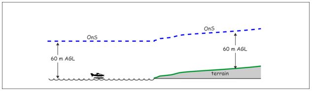
(1) Figure 1 provides an overview of the notification surfaces by illustrating a basic OnS of a fixed height of 60 m AGL with respect to terrain, and a modification to an incline OnS-A when in the vicinity of an aviation facility.
- (a) The aviation facilities to which this AC applies, are aerodromes and heliports listed in the Canada Flight Supplement (CFS) and the Canada Water Aerodrome Supplement (CWAS). Both of these supplements are available from NAV CANADA. Refer Visual Flight Rules (VFR) Publications.
- (i) Certified aerodromes are indicated in the OPR (Operator) sub-heading of the CFS by the abbreviation "Cert".
- (ii) non-Certified (Registered)aerodromes are indicated in the OPR (Reference) sub heading of the CFS by the abbreviation, "Reg".
- (iii) Aerodromes with IAP are indicated in the REF (Reference) sub-heading of the CFS by the abbreviations:
- CAP - Canada Air Pilot. or
- RCAP - Restricted Canada Air Pilot
Figure 1 – OnS Overview

4.2 Submittal if requested
(1) If requested by TCCA, an AAF is submitted.
4.3 On aerodrome property
(1) If the object is to be installed on aerodrome property, an AAF submittal is provided, regardless of height.
4.4 Basic OnS
(1) When away from the vicinity of an aerodrome, an AAF submittal is provided for any construction or alteration whose height is more than 60 m AGL at its site.
4.5 Vicinity of an aerodrome and heliport
(1) Within the vicinity of an aerodrome, an AAF is submitted for any construction or alteration that exceeds an imaginary surface OnS-A extending outward and upward:
- (a) for a Certified runway-type aerodromes (i.e. an airport) and Registered aerodromes having Instrument Approach Procedure (IAP), at a specified slope of 1% from a nearest runway edge out to a distance of 6000 m,
- (b) for a Registered runway-type aerodromes without IAP, at a specified slope of 2% from a nearest runway edge out to a distance of 3000 m, and
- (c) for a heliport. at a specified slope of 4% from the nearest FATO edge out to a distance of 1500 m.
4.5.1 Certified Runway-type Aerodrome and Registered Aerodromes with IAP
(1) As shown in Figure 2, for a Certified runway-type aerodrome and a Registered Aerodrome with IAP, the OnS-A has a slope of 1% for a horizontal distance of 6000 m from the nearest point of the nearest runway of each aerodrome, excluding heliports, and water aerodromes which don't have defined water channels.
- (a) Up to 6000 m, submittal is made when the overall AMSL height of the object is more than the calculated AMSL height of the OnS-A incline at the object location.
- (b) The AMSL value of runway elevation y0, at the start of the OnS-A, is an assigned value (refer 4.5.2).
- (c) Beyond 6000 m, the OnS-A reverts to the basic OnS for which submittal occurs when object height exceeds 60 m AGL.
- (d) An example calculation is provided in Annex A.
Figure 2 – OnS-A for Certified Runway-type aerodromes and Registered Aerodromes with IAP

4.5.2 Registered Aerodromes without IAP
(1) As shown in Figure 3, for a Registered runway-type aerodrome without IAP, the OnS-A has a slope of 2% for a horizontal distance of 3000 m from the nearest point of the nearest runway of each aerodrome, excluding heliports, and water aerodromes which don't have defined water channels.
- (a) Up to 3000 m, submittal is made when the overall AMSL height of the object is more than the calculated AMSL height of the OnS-A incline at the object location.
- (b) The AMSL value of runway elevation y0, at the start of the OnS-A, is an assigned value given in the CFS for the aerodrome elevation.
- (c) Beyond 3000 m, the OnS-A reverts to the basic OnS for which submittal occurs when object height exceeds 60 m AGL.
Figure 3 – OnS-A for registered aerodromes without IAP

4.5.3 Runway elevation y0
(1) The AMSL elevation y0 at the start of the OnS-A incline is an assigned value.
- (a) If the aerodrome (i.e. airport) has an AZR, the AMSL value of y0 is specified in the regulation as that of the Aerodrome Reference Point (ARP). These airports and their AZR can be found at the Aeronautics Act site.
- (b) If the aerodrome has Instrument Approach Procedures (IAP), the AMSL value of y0 is the elevation of the lowest point on the runway(s). Aerodromes with an IAP are indicated in the REF (Reference) sub-heading of the CFS by the abbreviations:
- CAP - Canada Air Pilot. or
- RCAP - Restricted Canada Air Pilot
- (c) The values of threshold elevations for aerodromes having IAP are shown in the NAV CANADA file Canada Airport Charts (CAC) which is available on the internet. The value for y0 is that of the lowest runway threshold elevation at the aerodrome and may not be that of the nearest runway related to the object location.
- (d) If the aerodrome doesn't have IAP, and is indicated only as "Reg" (Registered) in the OPR (Operator) sub-heading of the CFS, the elevation of the Aerodrome Geometric Centre (AGC) given in the CFS is used for the value of y0.
4.5.4 Heliports
(1) As shown in figure 4, the OnS-A for Heliports having instrument approach has a slope of 4% for a horizontal distance of 1500 m from the nearest point of the nearest Final Approach and Take Off (FATO) area of each heliport.
- (a) Up to a distance of 1500 m, submittal is made when the AMSL object height is more than the calculated AMSL height of the OnS-A incline at the object location.
- (b) Beyond 1500 m the OnS-A reverts to the basic OnS for which submittal occurs when object height exceeds 60 m AGL.
- (c) The AMSL value of the FATO elevation y0 is obtained from the CFS.
Figure 4 – OnS-A for heliports

4.5.5 Rising terrain
(1) The OnS-A incline may extend into rising terrain. When this occurs, the OnS-A will be below ground level at the object location. An AAF is still submitted as exceeding the OnS A.
4.5.6 Transportation Corridor
(1) The OnS-A criteria pertains to the height of objects. Highways, roads, railways, or other forms of transportation corridor for mobile objects, are to be considered as having an object AGL height, in accordance with Standard TP312.
4.5.7 Shielding
(1) You need not file an AAF for construction or alteration of any object that will be shielded by surrounding structures of a permanent and substantial nature or by natural terrain or topographic features of equal or greater height and will be located in the congested area of a city, town, or settlement where the structure so shielded cannot be accessed by an aeroplane-type aircraft following normal flight procedures.
4.6 Catenary
(1) A “catenary” is typically that of a high voltage transmission line with voltages of 69 kV or more. The transmission line crosses rivers, valleys, and other terrain features. It may also be applied for crossing facilities such as pipelines, railways, and other powerlines.
- (a) Powerlines of less voltage are typically used for local distribution and are usually installed along roadways that may pass by an aerodrome. These local distribution powerlines are also in the form of a catenary, but are treated as for other objects within the vicinity of an aerodrome or heliport. The obstacle height of the distribution powerline is that of the associated support poles.
- (b) As indicated in Figure 5, a AAF is submitted if any point along the transmission line cable is more than 60 m AGL above the terrain feature or facility directly below that point. When considering points above a river, the water height is the lowest expected level for that location.
- (c) Figure 5 illustrates a single catenary. Where the river or valley is relatively wide, there may be more than one catenary for a lengthy crossing, necessitating use of 3 or more support towers. In such instance, submittal of AAF is done for the section of the crossing which has points whose height exceeds the OnS criteria.
Figure 5 – Catenary – transmission line

4.7 Water aerodromes.
(1) Where a water aerodrome doesn't have a defined water channel, the OnS is at 60 m AGL as shown in Figure 6.
Figure 6 – Water aerodrome without defined water channel
(2) Where the water aerodrome has defined water channels, it is considered to be a runway and the Registered runway-type aerodrome without IAP criteria would apply [see section 4.5.2].
4.8 Windturbines and windfarms
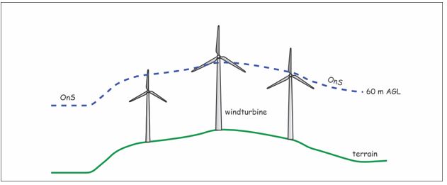
(1) As shown in Figure 7, submittal is made for windturbines and windfarms, if any portion [measured to the tip of a vertical blade] is more than the Basic OnS of 60 m AGL,
(2) Where some or all of the windturbines of a windfarm are within the vicinity of an aerodrome, submittal is made according to the established OnS-A incline and distance to the nearest point on the nearest runway or FATO. In such cases, submittal is made for the entire windfarm, even though only some of the windturbines are in the vicinity of the aerodrome and higher than the OnS-A.
Figure 7 – Windturbines and windfarms
(3) Meteorological Evaluation Towers (MET) used to measure a wind resource can be a hazard to low flying aircraft such as those engaged in aerial spraying activity. Therefore, MET towers should be included in the submittal for a windfarm [refer AC 601-005].
(4) Where MET towers are installed separately and prior to the construction of a windfarm, their location should be reported direct to the NAV CANADA Landuse Program. Subsequent dismantlement or movement to a new location of the MET tower should also be reported direct to NAV CANADA.
4.9 AZR and submittal of Legal land survey
(1) The OnS-A for runway-type land-aerodromes, at 1% incline, will likely be below the Outer Surface of an AZR. However, if the height of the object exceeds the OnS-A and the object is on lands affected by an AZR, a legal land survey attesting conformance may be required. The TCCA regional office can advise as to whether a legal land survey is required.
4.10 Alterations not submitted
(1) No notice is necessary for an alteration of:
- (a) a change of lighting configuration to a new configuration which is an allowed choice in Standard 621 for the specified mode of protection. For example, a change of adding white medium intensity lighting to avoid painting on towers less than 150 m in height.
- (b) A change from incandescent source lighting to LED source lighting within an existing lighting configuration. This is considered a maintenance activity.
4.11 Change of Ownership
(1) An AAF should be submitted when there is a change of ownership, for purpose of record.
5.0 Information management
(1) Not applicable
6.0 Document history
(1) Not applicable
7.0 Contact us
For more information, please contact:
E-mail: https://tc.canada.ca/en/corporate-services/regions
We invite suggestions for amendment to this document. Submit your comments to:
AART Documentation Services/
E-mail: AARTDocServices-ServicesdocAART@tc.gc.ca
Original signed by
Stacey Mason
Director, Standards branch
Civil Aviation
Annex 1 – Example, Runway-type Aerodrome
(1) Figure 8 illustrates an example for determining when to submit an AAF for a runway-type aerodrome. The aerodrome has two runways. Because of the object's location, the nearest point is to the side of the Northern runway. The OnS-A is 1%.
Figure 8 – Example - Runway-type aerodrome

(2) In the case of object A:
- (a) The elevations used in this example are in metric units (metres). The elevations given in the CFS and Canada Airport Charts (CAC) are in imperial units (feet).
- (b) The height y0 is an assigned value and may be below the elevation of the nearest point to the nearest runway as determined by the object location. Refer 4.5.2
(3) For example, Brampton-Caledon CNC3 has two runways 15-33 and 08-26 with threshold elevations of 936 ft, 910 ft, 925 ft, and 915 ft respectively. The assigned value of y0 is then 910 ft which is the lowest threshold
y1 = 285.2 m = measured AMSL height of the terrain at the object location (ground elevation)
y2 = 30.0 m = AGL height of object above ground at the project location
y3 = y1 + y2 = 315.2 m = overall AMSL height of the object
x3 = 1310.6 m = distance from the object location to the nearest point on nearest runway.
y0 = 910 ft = 277.4 m AMSL = the assigned runway edge elevation.
y4 = 0.01(x3)+y0 = 13.1+277.4 = 290.5 m = height AMSL of OnS-A at the object location.
Therefore:
The object overall height y3 exceeds the OnS-A height y4 by 24.7 m and an AAF is submitted.
(4) Object B is shown as located after 6000 m. Submittal of an AAF occurs when the height of the object exceeds the OnS of 60 m AGL.