This document lists all of Canada’s designated alternate ballast water exchange areas and the fresh waters referred to in the Ballast Water Regulations.
On this page
- Purpose
- Canada’s Ballast Water Regulations
- History
- Part 1: Where to exchange your Ballast Water
- Part 2: List of Canadian Fresh Water
Purpose
This document lists all of Canada’s designated alternate ballast water exchange areas and the fresh waters referred to in the Ballast Water Regulations.
Please note, the words and expressions in this document have the same meaning as in the Ballast Waters Regulations.
Canada’s Ballast Water Regulations
Canada’s regulations help reduce the chances that harmful aquatic organisms and pathogens are introduced to Canadian waters and help protect marine ecosystems.
When a new organism arrives in an ecosystem, it can create damage that cannot be undone. Sometimes, these organisms arrive in Canada through ballast water and damage our marine ecosystems and economy.
History
In 1982, the Department of Fisheries and Oceans created Canada’s first ballast water restrictions. These restrictions were developed to reduce the threat of toxic phytoplankton (tiny organisms that live in water) on local mussel farms around the Ile-de-la-Madeleine archipelago, an important environmental concern that had to be dealt with to avoid further damage to the marine ecosystem and economy at this time. The regulations have been updated many times since they were first created.
More information about the discharge requirements for the Iles-de-la-Madeleine archipelago could be obtained from the current Canadian Sailing Direction, ATL 108 - “Gulf of St. Lawrence (Southwest Portion)" (PDF, 55.1 MB).
Ballast Water then went on to be discussed more openly among nations, and in international forums as something that needed to be addressed. The harmful effects of unwanted species in vessel’s ballast water were first reported to the International Maritime Organization (IMO) in 1988, when Canada informed the Marine Environment Protection Committee (MEPC) about the presence of aquatic invasive species in the Great Lakes.
The first Canadian voluntary rules for ballast water exchange were created in 1989 for vessels traveling to the Great Lakes, and there have been many changes since
- in 1991 the MEPC adopted the first voluntary guidelines for preventing the introduction into the marine environment of unwanted aquatic organisms and pathogens from vessel’s ballast water and sediment discharges. Following the United Nations Conference on Environment and Development (UNCED) in 1992, the MEPC guidelines were reviewed and adopted as an Assembly Resolution in 1993 – these were revised and adopted in 1997 as resolution A.868(20), Guidelines for the Control and Management of Ships Ballast Water to Minimize the Transfer of Harmful Aquatic Organisms and Pathogens;
- in 2000 the Canadian guidelines were expanded to cover all Canadian waters and renamed to the Guidelines for the Control of Ballast Water Discharge from Ships in Waters under Canadian Jurisdiction;
- in 2004 the IMO finalized the International Convention for the Control and Management of Ships’ Ballast Water and Sediments, 2004 – this Convention created a standard for ballast water treatment and called for the eventual phasing out of ballast water exchanges;
- in 2006, Canada’s Ballast Water Control and Management Regulations were changed to reflect, to the maximum extent possible, the current United States (U.S.) and international rules, including the International Convention for the Control and Management of Ships’ Ballast Water and Sediments, 2004;
- in 2010 Canada ratified the International Convention for the Control and Management of Ships’ Ballast Water and Sediments, 2004;
- in 2011 and 2017 administrative changes were made to the Ballast Water Control and Management Regulations;
- in 2017, the International Convention for the Control and Management of Ships’ Ballast Water and Sediments, 2004 came into force; and
- in June 2021, Canada created new ballast water regulations. To support the changes in these regulations, this document was updated and renamed “List of Canada’s Designated Alternate Ballast Water Exchange Areas and Fresh Waters”.
Part 1: Where to exchange your ballast water
If your vessel enters waters under Canadian jurisdiction from somewhere other than the U.S. waters within the Great Lakes Basin, and it cannot exchange ballast water in a ballast water exchange area, then it will have to exchange ballast water in one of the areas listed below.
Canada’s ballast water exchange areas are:
- at least 200 nautical miles from the nearest land and where water depth is at least 2,000 m;
- an area described in, and in accordance with, regulation B-4.1 of the Annex, if the vessel cannot meet the requirements of paragraph (a); or
- in one of the alternate ballast water exchange areas designated by the Minister in TP 13617, if the vessel cannot meet the requirements of paragraph (a) or (b).
The maps included in this document are to show exchange zones, and are not meant to be used for navigational purposes.
Find the exact location of the Marine Protected Areas in Section A2 of the publication, Notices to Mariners 1 to 46, Annual Edition.

If you bring your vessel to a Canadian port, offshore terminal or anchorage area in the Great-Lakes Basin, St. Lawrence River or Gulf of St. Lawrence, between December 1 and May 1, you must exchange ballast water in the Laurentian Channel east of 63.00 west longitude where the water is at least 300 meters deep.
The area within the Laurentian Channel Marine Protected Area is located south of the western part of Newfoundland. The St. Anns Bank Marine Protected Area is located to the east of Cape Breton Island. The areas where the Laurentian and St. Anns Bank areas overlap, and the water is at least 300 meters deep can be used to exchange ballast water between December 1 and May 1.

If you bring your vessel to a Canadian port, offshore terminal or anchorage area on the East Coast of Canada, you must exchange ballast water in an area south of 43.50′ north latitude where the water is at least 1,000 meters deep.
Vessels travelling to or from the Bay of Fundy must exchange ballast water in the Gulf of Maine where the water is at least 100 meters deep. The area is between:
- 44.22 north latitude and 67.28 west longitude
- 44.10 north latitude and 66.90 west longitude
- with the Canada-United States border to the south.
Vessels crossing the Gulf of Maine or using a coastal route on the Scotian Shelf must exchange ballast water in the Gulf of Maine, where the water is at least 100 meters deep. The ballast water exchange area is:
- bound on the east by 43.10 north latitude and 66.45 west longitude
- 42.70 north latitude and 66.40 west longitude
- with the Canada-United States border to the west.
Vessels travelling to or from Nova Scotia, and vessels following a shelf break path must exchange ballast water where the water is at least 1,000 meters deep, west of Sable Island and the Gully, and away from the entrance to the North East Channel. The ballast water exchange area is:
- bound on the east by 43.40 north latitude and 60.25 west longitude
- 43.00 north latitude and 60.00 west longitude
- with the Canada-United States border to the southeast.

If you bring your vessel to a Canadian port, offshore terminal or anchorage area on the West Coast of Canada, ballast water is to be exchanged in an area at least 50 nautical miles west of Vancouver Island and Haida Gwaii, and at least 50 nautical miles west of a line that extends from Cape Scott to Cape St. James where the water is at least 500 meters deep.
Vessels cannot exchange water within 50 nautical miles of the Bowie Seamount, located west of Haida Gwaii. (53.30 north latitude and 135.66 west longitude) and the 2 small Maa-nulth fishing zones (Kyoquot and Barkley) located south-east of the designated alternate ballast water exchange area:
Coordinates of Maa-nulth Domestic Fishing Area Kyoquot Sound:
| Notch Point | Latitude | Longitude |
|---|---|---|
| 1 | 49.48N | 128.74W |
| 2 | 49.26N | 129.02W |
| 3 | 49.00N | 128.25W |
| 4 | 49.21N | 127.97W |
Coordinates of Maa-nulth Domestic Fishing Area Barkley Sound:
| Notch Point | Latitude | Longitude |
|---|---|---|
| 1 | 48.35N | 126.46W |
| 2 | 48.14N | 126.70W |
| 3 | 47.97N | 126.38W |
| 4 | 48.00N | 126.27W |

If you bring your vessel to a Canadian port, offshore terminal or anchorage area in the Eastern Arctic ballast water must be exchanged in an area offshore where the water is at least 1,000 meters deep, between latitudes 57.00 north and 75.00 north, and longitudes 56.00 west and 73.00 west.

If you bring your vessel to a Canadian port, offshore terminal or anchorage area in the Western Arctic ballast water must be exchanged in an area as far away from shore as possible, where the water is more than 100 meters deep.
The Tuvaijuittuq Marine Protected Area within the Western Arctic Designated Alternate Ballast Water Exchange Zones is located north of Melville Island in an area of the sea in the Arctic Ocean consisting of the waters off northern Ellesmere Island.
Part 2: List of Canadian fresh water
If you are managing ballast water to meet the ballast water performance standard, you cannot release ballast water into fresh waters unless the ballast water has been exchanged according to the Ballast Water Exchange Standard.
For the purpose of this requirement, Canadian fresh waters are the following:
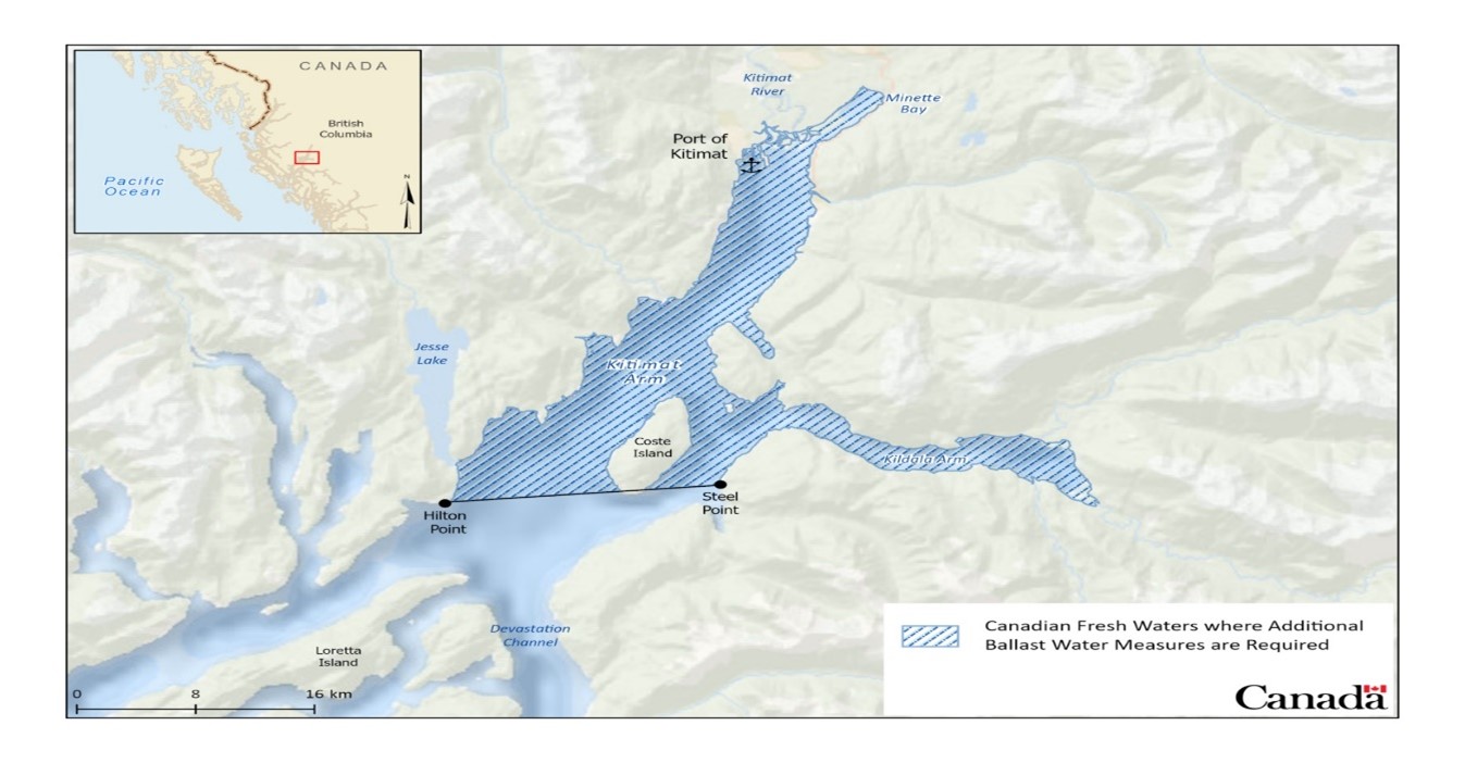
- the waters at the Port of Kitimat and waters in or upstream of the Kitimat Arm, east of a line between Hilton Point and Steel Point;
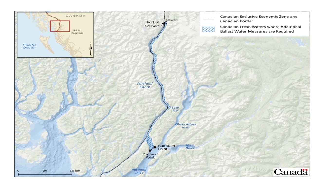
- the waters at the Port of Stewart and waters in or upstream of the Portland Canal, north of a line between Portland Point and Ramsden Point;
- the waters of all Fraser River ports that are:
- east of Tilbury Island in the main arm of the Fraser River including Annacis Island and New Westminster docking areas; and
- east of the eastern tip of Mitchell Island in the north arm of Fraser River;
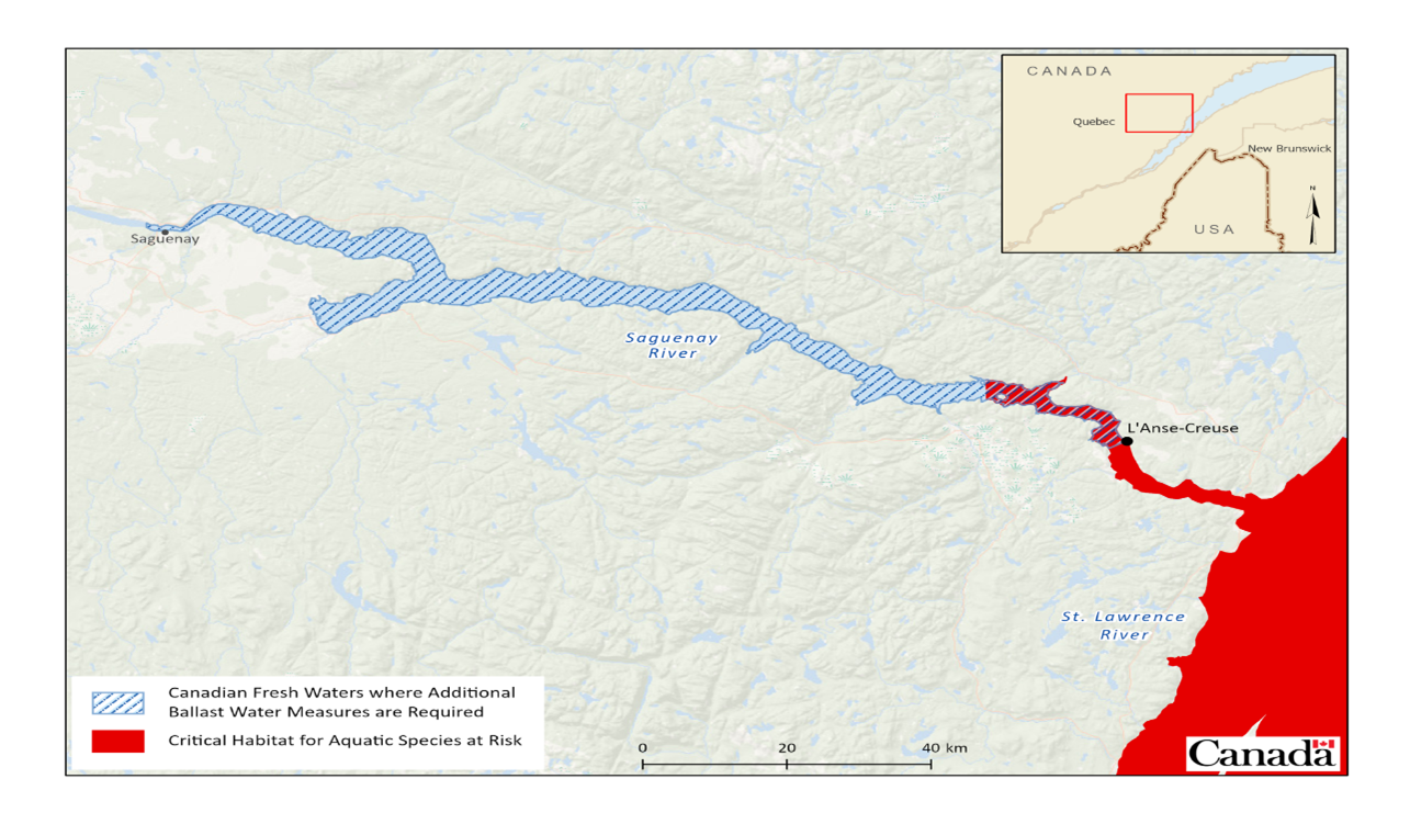
- the waters of the Saguenay River ports and waters upstream of L’Anse-Creuse;
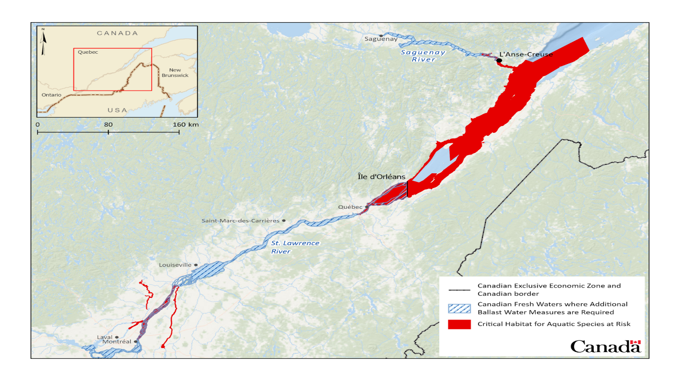
- the waters of all St. Lawrence River ports and waters west of the east point of Ile d’Orléans including the port of Quebec City;
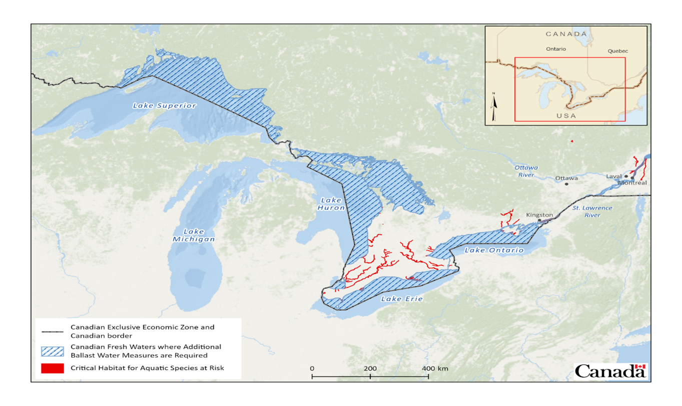
- all Canadian waters of the Great Lakes Basin; and
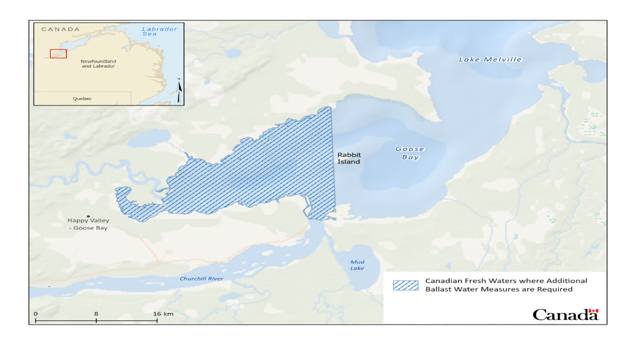
- the waters of Happy Valley-Goose Bay and waters of Lake Melville west of Rabbit Island.
Learn more about exceptions to these requirements in the Ballast Water Regulations.
The following maps show the specific Canadian fresh waters that fall under this requirement.
The maps in this document are to show exchange zones and are not meant to be used for navigational purposes.
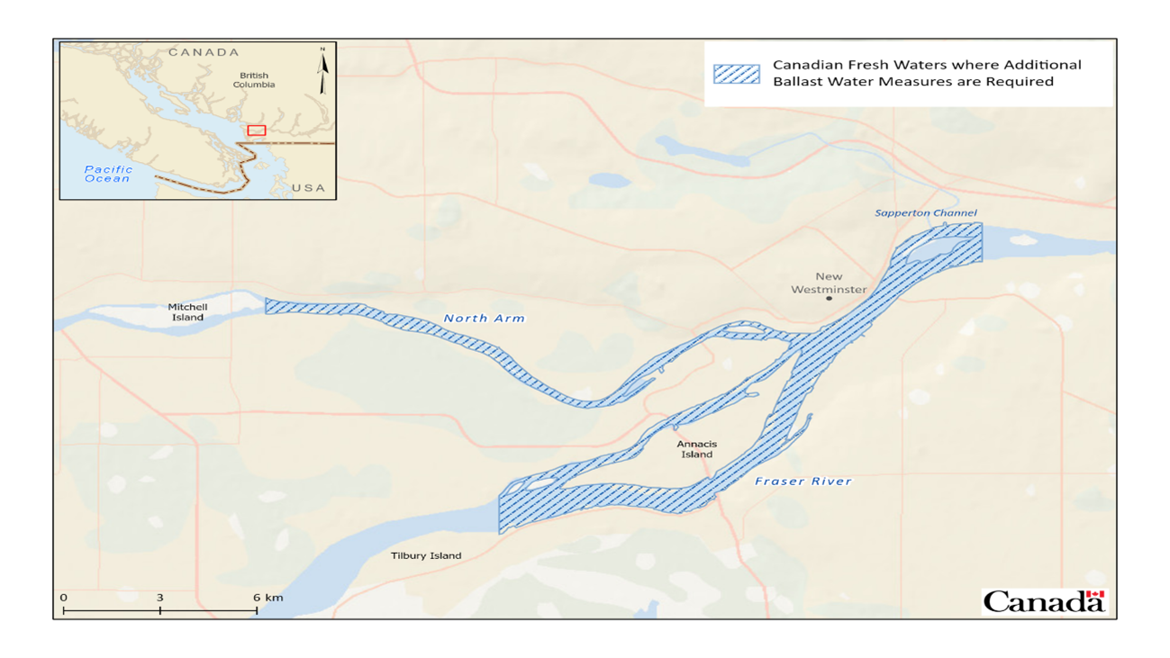
- east of Tilbury Island in the main arm of the Fraser River including Annacis Island and New Westminster docking areas, and
- east of the eastern tip of Mitchell Island in the north arm of Fraser River.