Public Consultation on the Hydrogeological Report
November 8, 2022
Introduction
- Objectives of this presentation:
- Provide a summary of the potential effects of the project on groundwater, private wells and wetlands in the area, as related to the Hydrogeological Report completed in May 2022 and the update to the project's Environmental Effects Evaluation;
- Present the planned mitigation measures that will be implemented to minimize the effects of the project on the environment; and
- Respond to your questions, comments and concerns.
Description of the project
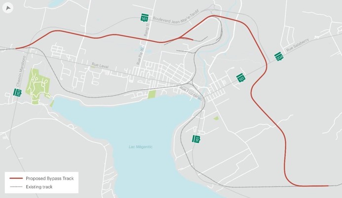
- 12.5 km rail bypass that will cross the municipalities of Nantes, Lac-Mégantic, and Frontenac.
- The bypass will connect to the industrial park, and will require a new bridge over the Chaudière River, before crossing a wooded area in Frontenac and will connect to the existing railroad.
- The existing rail line will be dismantled to allow for the reconstruction of downtown Lac-Mégantic.
Previous Steps
2015: Feasibility studies (study of needs and solutions)
Phase I: Opportunity study to identify potential corridors
2016: Notice of project filed with the Ministry of the Environment (MELCC)
Phase I report identifies and analyses potential corridors
2017: Phase II: Preliminary Design (2017-2018) evaluates three variations of the chosen corridor
Consultations with the Bureau d'audiences publiques sur l'environnement (BAPE)
2018: Announcement of funding for the project by the Premiers and the choice of the final route
2019: Tabling of Environmental Assessment Documents (2018-2019)
Consultations with the Bureau d'audiences publiques sur l'environnement (BAPE)
2020:Decision of the MELCC and the BAPE
Consultation with the Commission de protection du territoire agricole du Québec (CPTAQ)
Phase III: Final preliminary design to incorporate data obtained from field surveys and geotechnical work, and specified the selected track profile in the chosen corridor.
2021:Field work (geotechnical, archaeology, traffic, fish habitat, hydrogeology)
2022: Public consultations to complete the application to the Canadian Transportation Agency in January 2022, open house in June 2022, hydrology in November 2022
Field work sequence
- Field work was completed for this project
- The hydrogeological study made it possible to assess the area of influence for each sector where excavation work is necessary
July to November 2021: Drilling and installation of 40 monitoring wells
August to October 2021: Lugeon tests (assessment of bedrock hydraulic properties)
September to November 2021: In situ conductivity testing in the monitoring wells (assessment of loose soil hydraulic properties)
October to November 2021: Survey of groundwater levels
Ongoing: Long-term ground water monitoring and sampling program of private wells
Environmental mitigation measures
- Since the beginning of the project, several mitigation measures have been identified to reduce the potential environmental impacts of the project.
- The provincial environmental assessment process led by the Ministry of the Environment and the Fight against Climate Change (MELCC) and the Bureau d'audiences publiques sur l'environnement (BAPE), was completed in 2020 and identified 138 environmental mitigation measures that have been incorporated into the project.
- Following the progress of the project, additional measures have been added:
- Measures 139 to 149: To comply with the federal Species at Risk Act and following consultations with First Nations, particularly on archaeology.
- Measures A-1 to A-52: Additional mitigation measures identified during the Hydrogeological Report and Environmental Effects Evaluation processes.
- Measures B-1 through B-9: Additional mitigation measures identified by Transports Canada (TC) following the Hydrogeological Report, to ensure the quality and quantity of water in private wells and protect wetlands.
Summary of the Hydrogeological Report
Areas potentially affected by changes in groundwater levels
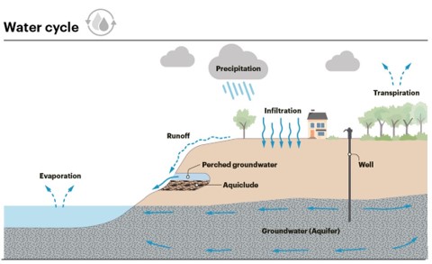
- A Hydrogeological Report was conducted to determine the potential impacts of the project on aquifers, focusing on the project excavation areas. Impacts were assessed as part of the environmental impact assessment.
- It was determined that the effects of the project on the water table could occur in the short and long term.
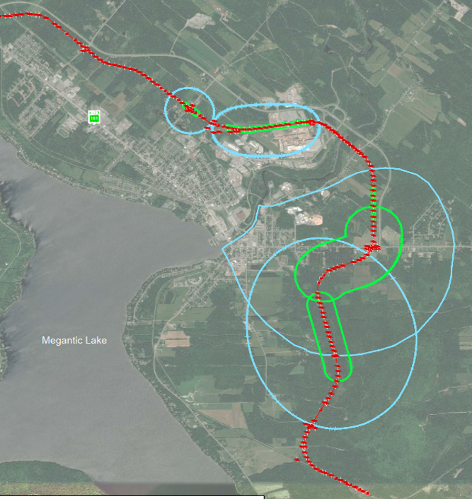
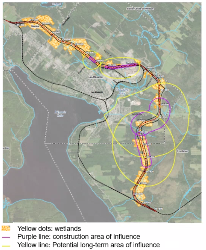
- Potential effects on groundwater and private wells are located in four main excavation areas.
- The green line illustrates the area of influence of the construction activities and represents the area with the greatest potential for lowering the groundwater level (between 2 and 10 m deep).
- The blue line illustrates the modeled potential long-term area of influence where impacts have a lower possibility of being observed (between 0 and 2 m drawdown, if at all).
- The project is not likely to have any impact on the municipal wells of Lac-Mégantic, Nantes or Frontenac.
Impacts on wells
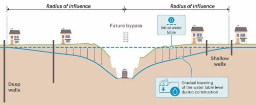
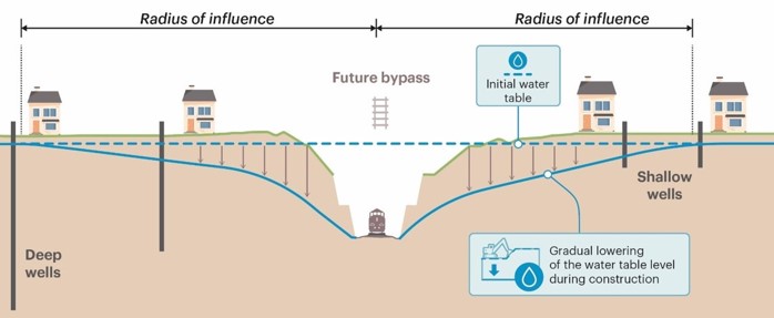
- The activities that are most likely to impact groundwater and wells are related to trench construction (excavation and blasting).
- Due to the lowering of the water table near the trenches, some surface wells could be depleted.
- Deep wells could experience a decrease in water volume and water quality could be affected in some areas.
- Mitigation measures have been identified to address the potential effects on water levels caused by construction activities on private wells.
Mitigation measures for wells
After reviewing the Hydrogeological Report, 8 additional mitigation measures were identified by TC to ensure water quality and quantity in private wells.
MELCC mitigation measures:
- #125: Make an inventory of all the wells located to a minimum of 200 metres of the right-of-way before the construction work begins.
- #127: If there is a significant impact to a well, a new or deeper well will be drilled to a greater depth at no cost to the owner.
TC added 1 additional mitigation measure:
- #B-1: In addition to the wells being inventoried and monitored within 200 metres of the right-of-way, wells located inside the potential long-term area of influence identified in the Hydrogeological Report will be inventoried to ensure that any potable water wells with potential risks are identified and documented.
Mitigation measures for wells
MELCC mitigation measure:
- #127: A well monitoring program will be implemented for at least two years after construction is completed.
TC added 5 additional mitigation measures:
- #B-2: If the water table has not stabilized by the end of the two-year time frame, then those at-risk potable water wells will continue to be monitored until stabilization occurs.
- #B-3: For the most at-risk receiving environments in terms of domestic water supply, dedicated observation wells will be installed and instrumented with data sensors to monitor the water level.
- #B-4: The groundwater monitoring program will establish intervention thresholds for groundwater level and quality prior to work commencing that will make it possible to quickly determine the extent of lowering of wells water levels at which it will be necessary to intervene in order to ensure a constant supply of drinking water to citizens.
- #B-5: Intervention thresholds will allow for rapid response to determine additional mitigation measures to be put in place and to ensure a safe water supply for residents. If despite this monitoring a well must be replaced under Measure 127 or if there is a water quality issue related to the bypass project, potable water will be provided at no cost until the situation is resolved or the new well is constructed.
- #B-6: Ensure potable water well water quality during the monitoring period. If potable water criteria are exceeded or quality decreased as a result of the works, water treatment systems will be installed as needed at no cost to the resident.
Mitigation measures for wells
MELCC mitigation measure:
- #130: If the situation requires, following validation by TC, specific mitigation measures must be identified and implemented. If necessary, these mitigation measures should be subject to additional monitoring to validate their effectiveness.
TC added 2 additional mitigation measures:
- #B-7: Data from the geotechnical and hydrogeological studies, such as borehole logs and groundwater levels, will be made available to the City of Lac Mégantic and the municipalities of Nantes and Frontenac for the purpose of updating its analysis of the vulnerability of drinking water supply sources.
- #B-8: Instrumented observation well(s) will be installed in a nearby watershed of similar nature, unaffected by the project (or by human withdrawals), to serve as a baseline to identify fluctuations in the water table caused by seasonal factors.
Impacts on wetlands
- Existing wetlands have been inventoried and are identified on the map in yellow dots.
- The effects of the project on wetlands will mainly affect the same four excavation areas. The construction of linear drainage ditches could, however, have impacts on other sectors of the project.
- Wetlands within the railroad right-of-way will be permanently destroyed and financial compensation of over $5 million will be paid to the Environmental Protection Fund.
- The drawdown of the water table could also have temporary or permanent effects on wetlands located outside the railway right-of-way.
- Mitigation measures have been developed to minimize the impacts of the project on wetlands outside the railway right-of-way.
Mitigation measures for wetlands
- Several mitigation measures are planned to reduce the direct and permanent loss of vegetation and wetlands, including measures to restore disturbed areas to recreate the original cover as soon as possible, and using native species for seeding and planting (MELCC measures #36 and #44).
- Additional measure #A-48: If the loss of wetlands outside of the right-of-way by the drawdown of the water table is unavoidable, compensate this loss with an additional payment to the Fonds de protection de l'environnement et du domaine hydrique de l'État.
Mitigation measures for wetlands
After review of the Hydrogeological Report, 1 additional mitigation measure was identified by TC to protect wetlands.
Mitigation measures identified during the Environmental Effects Evaluation and the Hydrogeological Report processes:
- #A-43: A follow-up on groundwater level variation close to wetlands should be performed for a period of two years following the end of the work.
- #A-10: If the drawdown of the water table affects drainage of wetlands outside the right-of-way and is related to surface water, consider damming the wetland to prevent complete drainage of the wetland.
TC added 1 additional mitigation measure:
- #B-9: Targeted ecological surveys will be conducted to identify wetland areas at risk that are of greater ecological importance.
Planned Next Steps
Fall 2022: Finalization of plans and specifications (100% complete)
Complete the land acquisition process with landowners
Winter 2023: Canadian Transportation Agency (CTA) review process begins
Call for proposals for construction work
Spring 2023: Obtaining regulatory approvals
(CTA, Fisheries and Oceans Canada, Navigable Waters Act, rail safety.)
Construction Phases
~36 months: Construction of the bypass
Operation of the bypass
12-18 months: Dismantling of the existing track
Transfer of land to municipalities
Public consultation on hydrogeology
Consultation period:
We would appreciate your comments in writing by November 25, 2022 to TC.InfoLacMegantic.TC@tc.gc.ca
Virtual information session:
Wednesday, November 9 from 6:00 - 8:00 pm
For more information about the project please contact us or visit https://tc.canada.ca/en/rail-transportation/lac-megantic-rail-bypass
Question period
We welcome your questions and comments
