Subject: Viewshed Analysis for Design of Aircraft Detection System (ADS)
| Issuing Office: | Civil Aviation, Standards |
|---|---|
| Document No.: | AC 601-006 |
| File Classification No.: | Z 5000-34 |
| Issue No.: | 01 |
| RDIMS No.: | 16779343-V3 |
| Effective Date: | 2021-05-19 |
Table of contents
- 1.0 Introduction
- 2.0 References and requirements
- 3.0 Background
- 4.0 Discussion
- 5.0 Summary
- 6.0 Information management
- 7.0 Document history
- 8.0 Contact us
List of figures
- Figure 1 – Terrain Masking
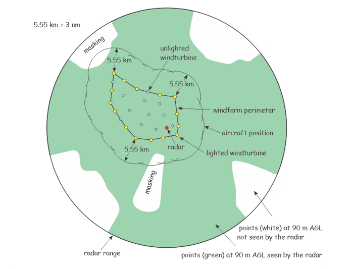
- Figure 2 – Viewshed Analysis with occasions of masking
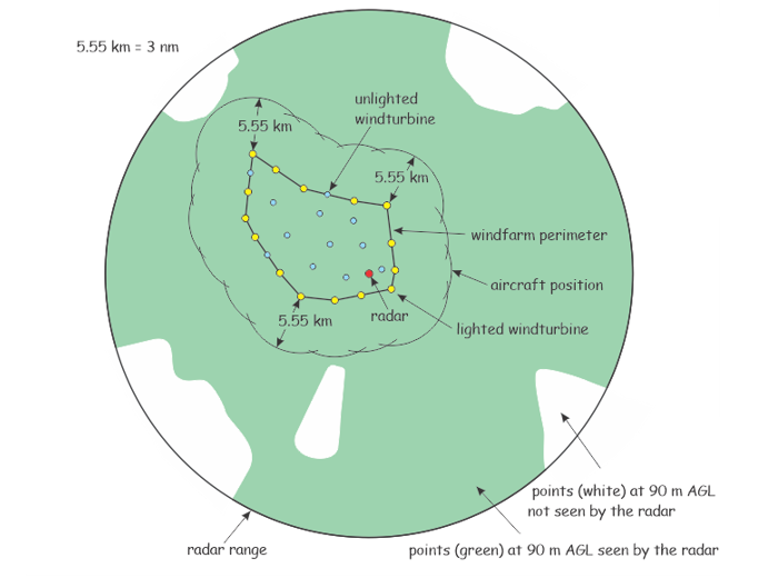
- Figure 3 – Viewshed Analysis with masking resolved
1.0 Introduction
- (1) This Advisory Circular (AC) is provided for information and guidance purposes. It describes an example of an acceptable means, but not the only means, of demonstrating compliance with regulations and standards. This AC on its own does not change, create, amend or permit deviations from regulatory requirements, nor does it establish minimum standards.
1.1 Purpose
- (1) This AC discusses viewshed analysis for an Aircraft Detection System (ADS) and provides minimum distance and height for the anticipated position of approaching aircraft that are to be detected.
1.2 Applicability
- (1) This AC is applicable to owners of windfarms who will be installing an ADS. This AC is also available for information purposes to Transport Canada Civil Aviation (TCCA) regional personnel and the aviation industry in general.
1.3 Description of changes
- (1) Not applicable.
2.0 References and requirements
2.1 Reference documents
- (1) It is intended that the following reference materials be used in conjunction with this document:
- (a) Part VI, Subpart 01, Division III of the Canadian Aviation Regulations (CARs) — Marking and Lighting of Obstacles to Air Navigation, Obstacles to Air Navigation, Sections 601.23 to 601.25;
- (b) Standard 621 of the CARs - Obstruction Marking and Lighting.
- (c) Aeronautical Assessment Form (AAF) #26-0427
2.2 Cancelled documents
- (1) Not applicable.
- (2) By default, it is understood that the publication of a new issue of a document automatically renders any earlier issues of the same document null and void.
2.3 Definitions and abbreviations
- (1) The following abbreviations are used in this document:
- (a) AAF: Aeronautical Assessment Form
- (b) ADS: Aircraft Detection System
- (c) CARs: Canadian Aviation Regulations
- (d) cd: Candela
- (e) km: kilometers
- (f) nm: nautical miles
- (g) TCCA: Transport Canada Civil Aviation
3.0 Background
- (1) Standard 621, Chapter 15, has requirements for an Aircraft Detection System (ADS).
- (2) The ADS is typically composed of a radar and an associated controller which turns ON the windfarm lighting when an approaching aircraft is detected. This is of benefit in reducing residential complaint due to glare that would otherwise be present should the lighting be ON continuously during twilight and night.
- (3) Chapter 15 of Standard 621 refers to detection in terms of a time period for the aircraft to reach the obstacle. However, the chapter doesn’t specify the ability of the radar to actually detect the aircraft and this may be jeopardized by terrain features which mask the radar signal. The purpose of this AC is to specify a minimum distance and height for the anticipated position of aircraft to be detected. If the signal is masked, it may be necessary to raise the radar or increase the number of radars at the site.
- (4) The specification of a height dimension is not to suggest that aircraft would normally be flying at this altitude during the night. It merely serves as a parameter by which to design the ADS.
- (5) In order to confirm to that the installed ADS will successfully detect aircraft, the proponent should provide a viewshed analysis with the Aeronautical Assessment Form (AAF), using the aircraft position dimensions provided herein.
4.0 Discussion
- (1) A windfarm is composed of numerous windturbines and one or more Meteorological (MET) towers. The outermost windturbines define the windfarm perimeter. The twilight and nighttime protection requirement is for a CL-864 red light installed on the nacelle [and CL-810 red lights at the mid-point of the mast for windturbines of more than 150 m height] of selected windturbines. The top lights having an output of 2000 candelas (cd) can be cause for residential complaint. One solution is to install a radar based ADS which turns the lights on when an approaching aircraft is detected. This is sometimes referred to as “on-demand lighting”.
- (2) It may occur, however, that intervening terrain masks the radar signal, as shown in Figure 1. This can be resolved by raising the radar or installing another radar. To do so is a matter of design and is dependent upon knowing the minimum position of the aircraft. That is, the height [h] AGL and distance [D] of the aircraft from the windfarm perimeter which is created by swinging radii of D meters from windturbines on the perimeter.
Figure 1 – Terrain Masking
Figure 1 - Text version
The figure 1 illustrates a profile of terrain between the windfarm radar and approaching aircraft. Two lines of different vertical angle are drawn from the radar towards the aircraft. The lower line is intercepted by rising terrain and thus the radar signal is “masked” and the aircraft would not be “visible”; that is, not detected by the radar. The higher angled line crests the terrain so that the aircraft is visible to the radar. In latter instance, the vertical height of the aircraft being detected is indicated as “h” AGL. This is at a given distance “D” from the windfarm perimeter. The minimum height “h” and distance “D” are provided by this AC to the designer. The figure implies that for the given minimum height of the aircraft, the radar may have to be raised to accommodate for terrain that would otherwise mask the signal.
-
(3) For application of ADS, the following design parameters for aircraft position are recommended:
h = 90 m AGL
D = 3 nautical miles or 5.55 km
- (4) When submitting an Aeronautical Assessment Form (AAF) the proponent should include, in the “Description of Project”, the viewshed analysis.
- (5) Figure 2 shows a viewshed analysis for which there are two occasions of masking. The masking is such that the aircraft is not detected until much closer to the windfarm. In this case, the masking is resolved by raising the radar with result as shown in Figure 3. If the masking cannot be resolved, the TCCA inspector may require some of the lighting to not be controlled by the ADS or that the use of ADS itself is not accepted.
Figure 2 – Viewshed Analysis with occasions of masking
Figure 2 - Text version
Figure 2 is a plan view that illustrates the viewshed around the windfarm out to the range of the radar which is the observer. All points for which the aircraft, at 90 meter AGL, would be “seen”, are coloured green. All points for which the aircraft at 90 meter AGL height would not been seen, due to masking terrain, are coloured white. For figure 2 some of the white areas extend closer in towards the windfarm perimeter than allowed by the required distance “D” which is 3 nautical miles or 5.55 kilometers from the perimeter.
Figure 3 – Viewshed Analysis with masking resolved
Figure 3 - Text version
Figure 3 is the result of adjusting the height of the radar. Because the radar is raised to a higher height, the plan view is altered, reducing the white areas for which the aircraft was previously not seen. This presents the acceptable design since aircraft are detected at the specified distance and minimum height.
5.0 Summary
- (1) For purpose of ADS design, the minimum aircraft position is at a distance of 5.55 km [3 nm] from the windfarm perimeter and at a height of 90 m AGL.
6.0 Information management
- (1) Not applicable.
7.0 Document history
- (1) Not applicable.
8.0 Contact us
For more information, please contact:
Civil aviation Regional offices
https://tc.canada.ca/en/corporate-services/regions
We invite suggestions for amendment to this document. Submit your comments to:
Civil Aviation Communications Centre
Civil Aviation Communications Centre contact form
Original signed by
Félix Meunier
Director, Standards
Civil Aviation


