
History/Contamination Details and Environmental Investigations to Date
Q1. What contamination is present at the TC-owned Port Facility and what is its source?
The most recent Environmental Site Assessment completed for the Fort Chipewyan Port Facility in 2017 documents known contamination from multiple sources including:
· creosote-treated lumber (in the Port Facility itself);
· historical use of bulk fuel storage tanks and distribution off-site on adjacent uplands of the site coupled with potential onsite fuel loading/unloading, launching and staging areas, on-site fill materials, on-site timber wharf and mooring structures with treated wood construction. This includes a former fuel distribution pipeline that ran from the Port Facility to off-site tanks; and
· at least 2 documented spills in the area with the largest in 1987 by a provincially regulated entity spilling 18,000 liters of diesel while loading fuel from /to the uplands storage facility off-site.
The waterlot sediments may have been further impacted by boating activities over the years, including boat fueling operations, discharge of contaminated bilge water, reports of a sunken barge, and potential deposition of sediments from off-site sources. Due to the design of the Port Facility, sediment from Lake Athabasca may also be deposited in the TC waterlot.
As a result, the Port Facility, the off-site bulk fuel storage site and former fuel spill site were found to have petroleum hydrocarbons (PHCs) and polycyclic aromatic hydrocarbons (PAHs) that are considered chemicals of concern among other related contaminants.
Details on the metals identified at the site are as follows:
· Soil - small areas of chromium impacted soil associated with multiple surface sources that could be found at a public wharf facility. Given that copper and arsenic were not elevated on-site, not likely from treated wood but other potential sources such as batteries, paints or fill material that may have been placed on-site.
· Groundwater - metals impacts are widespread in the groundwater across the site. Results are consistent with multiple sources that could be found at a public wharf facility combined with a large source of impact on the adjacent up gradient property.
· Sediment - given the potential for treated wood use on-site, the elevated arsenic concentrations in combination with the slightly elevated chromium and copper concentrations, may indicate that some treated wood has been used on-site.
The contamination identified at this site is typical of what can be found at commercial port facilities across the country with on-going activities, where fuel transfer/ distribution occurs, and where a wharf is constructed with creosote-treated lumber.
History of Environmental Investigations
Investigations have been conducted periodically at the facility since 1997 in accordance with the Federal approach to contaminated sites and environmental site assessment industry standards.
Phase I Environmental Site Assessment, Fort Chipewyan Public Port Facility, Fort Chipewyan, Alberta, Public Works and Government Services Canada, August 1997;
Phase II Environmental Site Assessment for Fort Chipewyan Public Wharf Facility, Fort Chipewyan, Alberta, Public Works and Government Services Canada, October 1998;
Phase I Environmental Site Assessment, Fort Chipewyan Public Port Facility, Fort Chipewyan, Alberta, EBA Engineering Consultants Ltd., January 2005;
Phase I ESA Update, Fort Chipewyan Public Port Facility, Fort Chipewyan, Alberta, Hemmera Envirochem Inc., October 2013;
Limited Phase II Environmental Assessment, Fort Chipewyan, Wharf Facility, Hemmera Envirochem Inc., February 2014;
Phase III Environmental Site Assessment Transport Canada – Wharf Facility Fort Chipewyan, Alberta, EGE Engineering Ltd., March 2017;
Human Health Preliminary Quantitative Risk Assessment & Ecological Risk Assessment, Transport Canda – Wharf Facility Fort Chipewyan, Alberta, Millennium EMS Solutions Ltd., March 2017; and
Remedial Options Analysis and Remedial Costs, Wharf Facility – Fort Chipewyan, Alberta, EGE Engineering Ltd. March 2017.
Summary of the Reports from the Environmental Investigations
A Phase I ESA is a historical review of information that identifies areas of potential environmental concern. A Phase II ESA is an initial testing program to investigate site conditions and to determine if there is a presence of contamination while a Phase III ESA is a detailed testing program to further delineate contamination.
A Phase I ESA was undertaken in 1997 and was updated in 2005 &2013. In 1998 & 2014 a Phase II ESA was undertaken, the results of which informed the scope of work for the Phase III ESA completed in 2017.
In 2017, TC completed a Phase III for the site. The Phase III was undertaken to determine the absence/presence of impacted soil, sediment and groundwater within the land and the waterlot portions of the property. Where identified, to delineate the extend and calculate the volume of contamination present. The results of the Phase III ESA do not indicate widespread soil impacts in the land lot portion of the site. The groundwater and sediment results indicated low level impacts consistent with the operation of a public wharf facility combined with a potential source of impact from the adjacent property. Remediation (dredging and excavation) was not recommended as the site remains an active public wharf facility. A risk assessment was recommended to be undertaken to determine if the impacted soil can be managed in place via monitored natural attenuation.
The Risk Assessment was also completed in 2017 based on the recommendations of the Phase III ESA with a remedial options analysis. The Risk Assessment incorporated results of previous studies dating back to 1997. The study concluded that the site did not pose human health risks from swimming, boat launching, or other recreational activities. The study noted that due to the site being an active wharf, remediation of sediments at the site was not likely to result in long term environmental improvement and would have resulted in short term disruption of the existing ecosystem. Based on these results, TC was confident that the site was safe for the current uses by humans and wildlife.
The Risk Assessment did note that a detailed quantitative aquatic risk assessment, including toxicity testing and/ or benthic community assessment, could be an option to evaluate whether contaminated sediments or groundwater has an effect on the aquatic ecosystem. The quantitative aquatic risk assessment was not pursued given the low level of risk identified in the Risk Assessment.
The Risk Assessment also noted potential risk to humans from groundwater. As part of the Phase III Environmental Site Assessment and the Risk Assessment, a desktop study was conducted in order to determine if any groundwater wells were present in close proximity to the Site. Both studies did not find any groundwater wells within 60 m of the facility.
Transport Canada viewed the potential risk from groundwater as very low because groundwater is expected to flow south toward Lake Athabasca, which means groundwater from our facility would move toward the Lake rather than upstream wells. Additionally, there are no groundwater wells at the facility and there are no properties between the facility and Lake Athabasca. Transport Canada conducted a search of the Alberta Water Well Information Database which confirmed that there were no wells in the immediate vicinity of the facility.
Based on the outcome of the Risk Assessment and conclusion that the facility was not likely to pose any risks to human health, and given that the facility has on-going activities with the potential for ongoing sources of contamination from fuel spills or from watercraft, Transport Canada did not pursue remediation.
A Remedial Options Analysis was undertaken to provide an assessment of remedial alternatives for the land lot and for the water lot including the advantages and disadvantages. Ex-situ remediation of 2,000 m3 of impacted soil or risk management was carried forward as options for the land lot. Remedial options for the water lot included dredging of 8,875 m3 of sediment or risk management. It was noted that active remediation would not prevent future contamination on the land lot from on-going use as a public wharf facility or from potential migration of contaminants onto the site from off-site sources.
Transport Canada continues to follow the Federal Approach to Managing Contaminated Sites, as it does with all sites. The uplands portion of the Fort Chipewyan site has not yet completed step 7 of the approach which requires the development of a remediation / risk management strategy. The subsequent step 8 is the implementation of the remediation / risk management strategy.
It is important to note that in some cases, the best approach may be to leave soil and sediments in place as disturbing the contamination may be riskier.
History/Contamination Details and Environmental Investigations to Date
Q2. Why were the Phase I and Phase II Environmental Site Assessments repeated?
Transport Canada generally updates previous environmental investigations for our facilities to verify the environmental conditions and adapt plans as needed. Transport Canada officials take into account site classification, potential for divestiture (and could also be influenced by changes to environmental standards, site conditions, potential for decisions to be made on the site, or other situations that could lead to a desire to update the information) funding and staff availability when determining the frequency of environmental investigations. Recently, studies have been revisited approximately every 5-10 years. This is a normal practice with contaminated sites. These regular updates allow Transport Canada to ensure that risks of contamination are understood and addressed.
History/Contamination Details and Environmental Investigations to Date
Q3. What happened between the Phase II ESA in 2014 and the Phase III ESA in 2017?
Following completion of the Phase II ESA in 2014, a Phase III ESA and Risk Assessment was executed in 2016 with the reports finalized in March 2017. As it was not designated a high-risk site, this work was prioritized and completed according to standard timelines and procedures.
History/Contamination Details and Environmental Investigations to Date
Q4. Were the previous studies conducted by qualified professionals?
The Risk Assessment was completed by qualified environmental professionals, with appropriate certifications, following industry standards, including guidance published by Health Canada and the Federal Contaminated Sites Action Plan. The Risk Assessment also considered a variety of uses such as swimming and fishing.
Consultants are pre-qualified by Public Services and Procurement Canada (PSPC) through the contracting process, and must meet mandatory requirements and demonstrate a strong understanding of the work. Both the engineering company and their staff are evaluated in the pre-qualification process and must show that they have the necessary years of experience, the technical background, and the project management expertise for similar projects that is needed to complete the work in line with industry standards and the specific requirements of the contracting process. In addition, a proposal specific to the work is developed and evaluated during the call-up process.
History/Contamination Details and Environmental Investigations to Date
Q5. Were the parties responsible for the spills held accountable? Was contamination remediated?
Many sources have contributed to the contamination at the Site, including two spills that occurred on the adjacent property to the north. Upcoming work will include reaching out to the appropriate parties, such as the province of Alberta, to determine next steps with respect to offsite sources of contamination. Transport Canada is committed to applying the polluter pays principle to the extent practical.
History/Contamination Details and Environmental Investigations to Date
Q6. Who will deal with contamination that has migrated outside of TC’s waterlot, regardless of the source?
Transport Canada is addressing the contamination that is present within its facility. Contamination outside of the property would be the responsibility of the appropriate parties, which would depend on the source of the pollution and the property owner(s).
History/Contamination Details and Environmental Investigations to Date
Q7. Where did TC disclose the Contamination?
Transport Canada has previously disclosed the presence of contamination at the Fort Chipewyan port facility. The facility has been listed on the publicly accessible Federal Contaminated Sites Inventory (FCSI) website since 2014. The facility is listed as an active site with identifier number 00026077 and can be found here (https://www.tbs-sct.gc.ca/fcsi-rscf/fsi-isf/00026077-eng.aspx).
Details on the FCSI note that the contamination at the facility consists of petroleum hydrocarbons (PHCs), polycyclic aromatic hydrocarbons (PAHs) and metals in the soil in the uplands portion of the site, and PAHs and metals in the sediment in the waterlot portion of the site. The volume of contamination is estimated as 2,050 cubic meters.
The overall site is a medium priority for action with the uplands portion as a Class 2 site and the waterlot as a Class 3 site low priority for action.
In addition to disclosure on the Federal Contaminated Sites Inventory, environmental reports that describe and address the contamination in greater detail have been previously shared with the Mikisew Cree First Nation and Fort Chipewyan Metis Local 125 in the context of interest expressed in acquiring the TC-owned port facility at Fort Chipewyan.
· the 2013 Phase I Environmental Site Assessment and 2014 Limited Phase II Environmental Site Assessment reports were shared with the Mikisew Cree First Nation and Fort Chipewyan Métis Local 125 in 2016.
· the 2017 Phase III Environmental Site Assessment, 2017 Human Health Preliminary Quantitative Risk Assessment & Ecological Risk Assessment, and 2017 Remedial Options Analysis and Remedial Costs reports were subsequently shared with the Mikisew Cree First Local 125 Nation in 2018.
The Risk Assessment was conducted to determine if human health and/or ecological risks exist as a result of exposure to pollutants in soil, sediment, and groundwater.
Additional Information Regarding Risk Assessements
Q8. How were Indigenous Uses considered in the 2017 Human Health Preliminary Quantitative Risk Assessment and Ecological Risk Assessment?
While the 2017 Human Health Preliminary Quantitative Risk Assessment and Ecological Risk Assessment identified the land use as commercial, it also recognized other uses such as swimming, fishing, and food gathering (Section 2.2 Land Use, page 7). The report considered potential risks to human health based on anticipated future use of the affected areas (Section 3.0 Risk Assessment Methodology, page 11). The report specifically considered ingestion of country foods, which is atypical for an exposure pathway in a commercial use scenario (Section 4.2.3 Human Receptors, page 17).
The Risk Assessment considered the following potential human exposure pathways: potable groundwater ingestion, indoor vapour inhalation, outdoor vapour inhalation, ingestion of country foods, direct soil contact, direct sediment contact, and direct surface water contact (Section 4.3.1 Human Exposure Pathways, pages 22-23).
Ingestion of country foods was excluded as an exposure pathway because the upland is covered with gravel and foraging is not expected. Additionally, wildlife and fish are not anticipated to significantly accumulate contamination since their home range is small relative to the facility (Section 4.3.1 Human Exposure Pathways, page 23).
Direct contact with sediment was excluded as an exposure pathway because exposure potential was low and the contaminant exposure was expected to be negligible. Additionally, sediment concentrations were below human direct contact soil guidelines (Section 4.3.1 Human Exposure Pathways, page 23).
Direct contact or incidental ingestion of surface water was excluded as an exposure pathway, which included consideration of boat launching, swimming or other recreational activities. The Risk Assessment anticipated that any contaminants related to the facility would be sufficiently diluted due to the size of Lake Athabasca (Section 4.3.1 Human Exposure Pathways, page 23).
Additional Information Regarding Risk Assessements
Q9. What Methodology was used for Risk Assessment?
The risk assessment methodology followed was consistent with guidance laid out by Health Canada (2012), Canadian Council of Ministers for the Environment (CCME) and the Federal Contaminated Sites Action Plan (2012).
The risk assessment methodology adhered to the standard health risk assessment paradigm and consisted of the following four steps: 1) problem formulation; 2) exposure assessment; 3) toxicity assessment; and, 4) risk characterization (Section 3.0 Risk Assessment Methodology, page 12).
The Risk Assessment concluded that the facility did not pose risks to human health from swimming, boat launching, ingestion of country foods (fish and wildlife), or recreational activities. This was primarily due to the levels of contamination being relatively low, and the small size of the facility relative to the habitat of the fish in Lake Athabasca which would limit uptake of contaminants present at the site. The Risk Assessment also concluded that there were no likely adverse risks to wildlife.
Additional Information Regarding Risk Assessements
Q10. What does a Human Health Preliminary Quantitative Risk Assessment and Ecological Risk Assessment typically consider?
A human health and ecological risk assessment defines and quantifies the risk to human health and the environment. It looks at the
· type, amount and location of substances present;
· presence of people or wildlife who visit or live on or near the site;
· routes of exposure; and
· physical and environmental characteristics of the site.
Three components must be present for potential risks to exist:
1. Contaminants must be present at concentrations sufficient to cause a possible adverse effect;
2. A receptor e.g. people, wildlife must be present; and
3. There must be a complete exposure pathway by which the receptor can come into contact with the contaminant.
Drinking Water
Q11. Are there drinking water wells nearby? Why was the area surrounding the wharf not checked for any groundwater wells in person
As part of the Phase III Environmental Site Assessment and the Risk Assessment, a desktop study was conducted in order to determine if any groundwater wells were present in close proximity to the Site. Both studies did not find any groundwater wells within 60 m of the facility. Transport Canada confirmed this finding on the Alberta Well Water Inventory. The perimeter of the closest residence to the site is also greater than 60 m away from the facility. At this site, groundwater is expected to flow south toward Lake Athabasca, which means groundwater from our facility would move toward the Lake rather than any upstream wells. Additionally, there are no groundwater wells at the facility and there are no properties between the facility and Lake Athabasca. Based on this, Transport Canada determined that it was highly unlikely that groundwater wells used for drinking water were present within 60 m of the Site.
Drinking Water
Q12. What is the impact on drinking water quality?
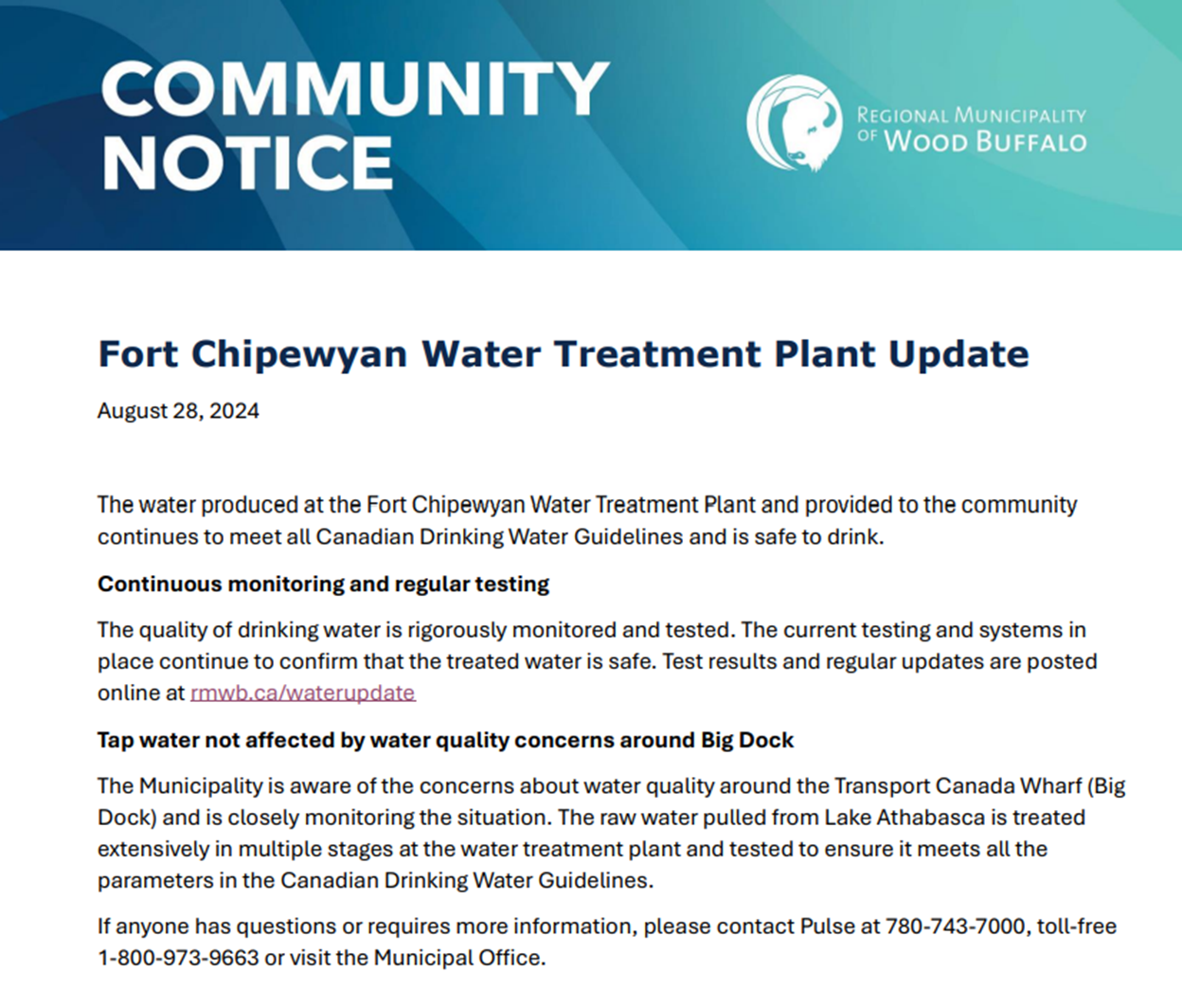
The potable water in Fort Chipewyan is safe to drink. The Regional Municipality of Wood Buffalo (RMWB) is responsible for the provision of drinking water for the local community.
The Regional Municipality of Wood Buffalo is aware of community concerns and have addressed them in an August 28th community notice advising that the water is tested extensively, and it is safe to drink. The Regional Municipality of Wood Buffalo pulls its drinking water from Lake Athabasca. It is treated extensively in multiple stages at the water treatment plant and tested to ensure it meets all the parameters in the Canadian Drinking Water Guidelines.
How are Contaminated Sites Assessed?
Q13. How are contaminated sites classified?
Contaminated sites are classified using the Canadian Council of Ministers of the Environment (CCME) National Classification System (NCS) or the Aquatic Sites Classification System (ASCS) published by FCSAP. The NCS/ASCS is a tool used to prioritize contaminated sites. Sites are categorized as Class 1, Class 2, Class 3, Class N or Class I.
• Class 1 sites are a High Priority for Action with potential impacts to human health and the environment i.e. sites with higher concentrations of contaminants, movement of contaminants off-site, impacts to drinking water etc.
• Class 2 sites are a Medium Priority for Action and may still pose a risk, but the risks are not as imminent to human health and the environment.
• Class 3 Low Priority for Action sites tend to be smaller in scale, more remote, and are less complex.
• Class N are Not a Priority for Action and no further action is required.
• Class I Insufficient Information indicates that further investigation is required to classify the site.
Further action to address concerns i.e. further site characterization, remediation, risk management etc.
How are Contaminated Sites Assessed?
Q14. What is the federal contaminated sites process?
The 10-step process provides a common approach to managing contaminated sites.
Figure 1 Steps for Addressing a Contaminated Site From the Federal approach to contaminated sites - Canada.ca
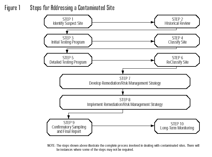
Step 1 - Identify Suspect Sites: Identifies potentially contaminated sites based on activities (past or current) on or near the site.
Step 2 - Historical Review: Assembles and reviews all historical information pertaining to the site.
· To meet this requirement, a Phase I Environmental Site Assessments (ESAs) was undertaken in 1997 and updated in 2005 & 2013 by TC.
Step 3 - Initial Testing Program: Provides a preliminary characterization of contamination and site conditions.
· TC undertook a Phase II ESA in 1998 and updated the study in 2014 to identify the contamination at the site.
Step 4 - Classify Contaminated Site Using the CCME National Classification System: Prioritizes the site for future investigations and/or remediation/risk management actions.
· Fort Chipewyan identified as Highest Step Completed 4 in 2014-15 & 2015-16.
· The uplands portion of the site is a Class 2 medium priority for action while the waterlot is a class 3 with a low priority for action.
Step 5 - Detailed Testing Program: Focuses on specific areas of concern identified in Step 3 and provides further in-depth investigations and analysis.
· TC undertook a Phase III ESA in 2017 to characterize the contamination at the site. A Human Health and Ecological Risk Assessment was also undertaken in 2017.
Step 6 - Reclassify the Site Using the CCME National Classification System: Updates the ranking based on the results of the detailed investigations.
· Fort Chipewyan reached Highest Step Completed 6 in 2016-17 and remains at this step.
· The uplands portion of the site is a Class 2 medium priority for action while the waterlot is a class 3 with a low priority for action.
Step 7 - Develop Remediation/Risk Management Strategy: Develops a site-specific plan to address contamination issues.
Step 8 - Implement Remediation/Risk Management Strategy: Implements the site-specific plan that addresses contamination issues.
Step 9 - Confirmatory Sampling and Final Reporting: Verifies and documents the success of the remediation/risk management strategy.
Step 10 - Long-Term Monitoring: If required, ensures remediation and long-term risk management goals are achieved.
How are Contaminated Sites Assessed?
Q15. How do other departments manage similar sites?
Federal contaminated sites are typically managed according to a common Ten Step Approach that lays out the steps to address a contaminated site from identification, assessment, development & implementation of a remediation/risk management strategy, long term monitoring and site closure. Further guidance is found in the Federal Contaminated Sites Decision Making Framework, and the Guidance for Assessing and Managing Aquatic Contaminated Sites in Working Harbours that complements the Ten Step approach. TC applies these frameworks.
Each department is responsible for managing their own sites but work collaboratively with expert support departments when needed. ECCC, HC and DFO are available to provide expert advice when asked and they develop and promote best practices so that Custodians adopt a consistent approach to human health and ecological risk assessments.
How are Contaminated Sites Assessed?
Q16. What does a Human Health Preliminary Quantitative Risk Assessment and Ecological Risk Assessment typically consider?
A human health and ecological risk assessment defines and quantifies the risk to human health and the environment. It looks at the
· type, amount and location of substances present;
· presence of people or wildlife who visit or live on or near the site;
· routes of exposure; and
· physical and environmental characteristics of the site.
Three components must be present for potential risks to exist:
1. Contaminants must be present at concentrations sufficient to cause a possible adverse effect;
2. A receptor e.g. people, wildlife must be present; and
3. There must be a complete exposure pathway by which the receptor can come into contact with the contaminant.
Communications with Indigenous groups and Engagement
Q17. Did Transport Canada conceal information about contamination at the Port Facility?
Information about the presence of contamination at Transport Canada-owned lands at Fort Chipewyan is publicly available. The Port Facility has been listed on the Federal Contaminated Sites Inventory since 2014, which is publicly accessible and includes details about contaminants. All previous assessments, including the most recent 2017 assessment, found that the site does not likely pose risks to human health.
Note that if any risk to human health, or the potential for the contamination to migrate offsite had been identified, or if Transport Canada had determined that remediation were required for the site, the department would have initiated communications with local Indigenous groups and relevant stakeholders at this time to advise of the environmental situation, and proposed approach to address contamination.
The environmental reports that address the contamination in detail have previously been shared with the Mikisew Cree First Nation and Fort Chipewyan Métis Local 125 in the context of interest expressed in acquiring the Transport Canada-owned port facility at Fort Chipewyan:
· The 2013 Phase I Environmental Site Assessment and 2014 Limited Phase II Environmental Site Assessment reports were shared with the Mikisew Cree First Nation and Fort Chipewyan Métis Local 125 in 2016.
· The 2017 Phase III Environmental Site Assessment, 2017 Human Health Preliminary Quantitative Risk Assessment & Ecological Risk Assessment and 2017 Remedial Options Analysis and Remedial Costs reports were subsequently shared with the Mikisew Cree First Nation in 2018.
Based on the outcomes of the ESA and Risk Assessment and the conclusion that the facility was not likely to pose any risks to human health or the environment, Transport Canada did not communicate the results directly to the Athabasca Chipewyan First Nation or the broader community immediately upon completion of the reports. We understand and regret the concern that this caused. Transport Canada recognizes the concerns with impacts of contamination and is committed to working with Fort Chipewyan Métis Local 125, Mikisew Cree First Nation, and Athabasca Chipewyan First Nation to establish mutually acceptable protocols for sharing in the future.
Communications with Indigenous groups and Engagement
Q18. How does TC determine whether to engage Indigenous groups regarding contaminated sites?
TC’s current practice to determine the approach to Indigenous engagement is to assess for potential interest in the site. This includes assessing whether there is interest from a claims perspective (in areas with active claims); interest in acquiring the site through divestiture; and the potential for migration of contaminants offsite, and potential for impacts on human health. This assessment would also take into account the nature of the site, including whether it is for commercial or industrial use, and whether it is a site with restricted access. In addition to the three areas identified above, TC would also assess the potential use of the site for cultural practices.
The threshold that informs the decision for Indigenous engagement has evolved over time. In the past, the decision to engage Indigenous groups would have been assessed from a perspective of a Duty to Consult and would have only been triggered in the context of a physical activity i.e. remediation, or negotiations regarding potential acquisition of a site. Given the Government’s priority for reconciliation with Indigenous peoples, which is highlighted through the Minister of ECCC's mandate letter commitment to prioritize sites in proximity to Indigenous communities for assessment and remediation, Transport Canada is now more actively engaging Indigenous communities earlier in the 10-step federal contaminated sites process.
.
Communications with Indigenous groups and Engagement
Q19. How has the use of the facility by Indigenous Communities been included in the studies to date and considered in plans for remediation?
Within the Risk Assessment, the level of risk was evaluated against commercial environmental standards consistent with the land use of the facility as a commercial port. Given the potential for recreational activities and other uses by the local community, activities such as fishing, swimming, and ingestion of country foods were also included in the Risk Assessment. The Risk Assessment concluded that the facility did not pose risks to human health from swimming, boat launching, ingestion of country foods (fish and wildlife), or recreational activities.
TC understands the Nations have a strong interest in being involved in environmental work at the site moving forward.
Communications with Indigenous groups and Engagement
Q20. Did TC have a Duty to Consult with Indigenous groups?
The Duty to consult is triggered when there is Crown conduct that may impact aboriginal or treaty rights. While the duty to consult was not triggered in this case, TC recognises that our lack of proactive communication left the Nations feeling concerned. TC now better understands the impact that this had, and the interests of the Nations in understanding the environmental conditions around the dock. TC has reached out to the Nations to offer to develop an information-sharing protocol with these Nations. In addition, TC will work with the Nations to ensure their full involvement in the planned environmental investigations.
Additional context:
TC did not have a duty to consult with the Indigenous groups. The duty to consult is triggered when Crown conduct could impact established or asserted section 35 or treaty rights.
TC recognises Mikisew Cree First Nation and Athabasca Chipewyan First Nation’s Treaty 8 rights in the area as well as the section 35 rights asserted by Fort Chipewyan Métis Nation.
Activities associated with previous environmental work would be considered Crown Conduct but would not have impacted the asserted section 35 or treaty rights of these Indigenous groups.
The 2017 Risk Assessment concluded that the facility did not pose risks to human health from swimming, boat launching, ingestion of country foods (fish and wildlife), or recreational activities. While it is possible that awareness of the environmental conditions could have discouraged the Nations from harvesting in the area (due to perception of environmental contamination), the contamination present at the facility is from a variety of sources and is not linked to Transport Canada conduct.
Communications with Indigenous groups and Engagement
Q21. Has TC impacted the treaty rights of the Indigenous groups?
Transport Canada has not impacted the treaty rights of the Indigenous groups. TC recognises Mikisew Cree First Nation’s and Athabasca Chipewyan First Nation’s Treaty 8 rights in the area. The Treaty protects these Nations’ ability to hunt, trap or fish in the area.
Communications with Indigenous groups and Engagement
Q22. Why did TC not respond to the Nations August 2024 letter to the Minister of Transport earlier?
Transport Canada has been engaging with the Nations regarding the Fort Chipewyan Port Facility since 2013 regarding potential acquisition of the Port Facility. This engagement continued until June 2022. Through the course of these engagements, environmental reports were shared with Mikisew Cree First Nation and Fort Chipewyan Métis Nation.
Transport Canada met in May 2024 to discuss the request for dredging at the Port Facility. Following receipt of the August 23rd letter, the department sought to engage with the Nations in October to discuss their concerns. The Minister of Transport subsequently held a call with the Nations in early October.
Communications with Indigenous groups and Engagement
Q23. Why can’t TC provide funds to the Indigenous communities to undertake the work themselves?
TC will pay for environmental assessments that would be completed in collaboration with the Nations. Given our understanding of the significance of the Nations concerns and the urgency they have expressed to have this work move forward, TC has worked with PSPC to secure an environmental management professional to undertake the initial phase of this work in a timely manner. TC recognizes concerns with trust, and will provide capacity funding to the Nations that could be used to retain independent third-party experts. Decisions on the best approach to manage the contamination for both the uplands portion of the site and the waterlot will be informed by Nations’ views and any recommendations of independent third-party experts retained by the Nations. As previously noted, TC is committed to working meaningfully with the Nations and is committed to providing capacity funds to ensure the Nations can meaningfully participate in this work.
Communications with Indigenous groups and Engagement
Q24. Has TC considered the cumulative impact of the contamination to the Nations?
Investigations have been conducted at the facility starting in 1997 in accordance with the Federal approach to contaminated sites and environmental site assessment industry standards. Risks to human health or the environment have not been identified to date. Transport Canada will be discussing contamination concerns with the Nations and is interested in understanding more about the concerns with cumulative impacts and how they could inform the upcoming studies and discussions.
Communications with Indigenous groups and Engagement
Q25. Is Transport Canada part of the community led studies announced by Minister Guilbeault?
The community-led health study, with the Athabasca Chipewyan First Nation, the Mikisew Cree First Nation and the Fort Chipewyan Métis Nation, will examine the impacts of the oil sands on community members’ health. The design of the community-led health study, currently underway, will outline the communities’ objectives and study methodology. They may include an assessment of whether there are heightened risks for cancer and other health and environmental impacts for downstream communities related to activity in the oil sands region.
TC is not currently participating in the study. ECCC, HC and ISC are supporting this community-led study which is assessing health risks associated with living near the Athabasca oil sands region, which is upstream from TC’s Fort Chipewyan Port Facility. TC is available to support this study.
Current Status and Next Steps
Q26. What is the scope of the environmental work to be undertaken?
This initial phase of environmental work includes a review of the historical reports, and recommendations on next steps to address data gaps and site investigations. The deadline for the completion of this initial phase of work is March 5, 2025. By early summer 2025, the department anticipates completing the environmental investigations which will reflect collaborative discussions and work with the Nations. This work will result in concrete options to manage the contamination for both the uplands portion of the site and the waterlot. The next steps in terms of remedial activities will depend on these environmental investigations. TC recognizes the urgency of undertaking this assessment and has secured an environmental management professional to initiate this work.
Current Status and Next Steps
Q27. How is TC going to engage with the Indigenous groups going forward?
TC understands the Nations have a strong interest in being involved in environmental work at the site moving forward. Transport Canada recognizes the importance of working meaningfully and collaboratively with the Nations in this important work. We have reached out to the Nations to share copies of all previous environmental reports and to set up a meeting to better understand how they would like to be involved in this work.
Transport Canada is committed to working with the Nations to ensure that traditional uses and traditional knowledge are identified and considered in future work at the facility and we will seek their guidance on the appropriate means and protocols to gather traditional knowledge and traditional use information for full consideration in the studies.
We have contacted the Nations to initiate conversations to determine how we can work together to collect and meaningfully incorporate their perspectives, while taking into account any sensitivity around this information. Traditional knowledge and traditional use information surrounding the site will help strengthen the analysis and results of the environmental reporting, and in turn provide Transport Canada with a better understanding of how Transport Canada’s port facility is tied to the local ecosystem and impacts to the Indigenous community.
The department is committed to providing capacity funding to support the Nation’s meaningful participation in this work. Going forward, the Nations will determine how they would like to be involved.
TC will work with the Nations to identify activities requiring involvement of the Nations and appropriate funding amounts to ensure meaningful participation this may include input into scoping of the studies, work plan and timelines, having TC’s studies reviewed, or undertaking independent studies alongside TC’s investigations. We will also ask for guidance on appropriate means and protocols to gather traditional knowledge and traditional use information for full consideration in the studies.
Current Status and Next Steps
Q28. Why does TC need to review the studies and not undertake remediation now?
TC is reviewing the studies in order to determine if remediation is the best course of action. Updated assessments may indicate that contamination is migrating to the TC-owned uplands from non-TC-owned lands (e.g., from the adjacent property to the north historically operated by multiple oil companies, contained numerous above ground fuel storage tanks, and experienced multiple fuel spills). TC would need to coordinate with provincial authorities and steps would need to be taken by the responsible party to address this before the remediation of the uplands would proceed. If remediation were to occur immediately, TC risks the facility being re-contaminated if the source of the contamination is off-site. Should a decision ultimately be taken/confirmed to remove soil from the uplands, this work will take place as soon as a contractor can be retained. TC will work with the Nations to have this work take place as soon as possible.
Current Status and Next Steps
Q29. When will the work start?
The environmental investigation has begun. On November 19th, 2024, Transport Canada retained a qualified environmental management professional through Public Services and Procurement Canada (PSPC) to address the contamination at the facility. This will allow TC, in collaboration with the Nations, to determine the best approach to manage the contamination for both the uplands portion of the site and the waterlot.
Current Status and Next Steps
Q30.What is the timeline for remediation?
By early summer 2025, the department anticipates completing the environmental investigations which will reflect collaborative discussions and work with the Nations. The environmental investigation currently underway will determine the best approach to manage the contamination for both the uplands portion of the site and the waterlot.
Decisions regarding remediation will be informed through the collaborative approach to be taken with the Nations, as well as future plans for the site, including the potential transfer to the Nations or a third party. Remedial options could include long-term monitoring of sediments and groundwater and/or soil removal where warranted. It is important to note that in some cases, the best approach may be to leave soil and sediments in place as disturbing the contamination may be riskier.
Current Status and Next Steps
Q31. How much has TC spent investigating the facility?
TC spent $130.7K from 2015-16 to 2016-17 to undertake detailed testing and site classification.
Current Status and Next Steps
Q32.What is the cost of the environmental work in 2024-25?
PSPC awarded a contract for the work on November 21, 2024 for an amount of $314K
(Consultant Call-up: $240K, PSPC Fees: $74K).
Current Status and Next Steps
Q33. Will TC provide capacity funding?
TC will provide capacity funding to the Nations to support their meaningful participation. TC will work with the Nations to identify activities requiring involvement of the Nations and appropriate funding amounts to ensure meaningful participation.
Current Status and Next Steps
Q34. Will TC engage federal experts in the assessment and remediation?
We are engaging federal experts from departments including Public Services and Procurement Canada (PSPC), Environment and Climate Change Canada (ECCC), Health Canada (HC), and Fisheries and Oceans Canada (DFO) to provide technical advice to addressing contamination at the facility.
Current Status and Next Steps
Q35. What is the role/interest of federal enforcement?
TC provides information on its contaminated sites to other federal departments, other levels of government or enforcement bodies when requested. This could include the status of investigations and next steps.
Other Contaminated Sites
Q36. How many contaminated sites does TC have?
A history of commercial and industrial activity has resulted in contaminated sites at facilities operated or managed by Transport Canada. TC has 238 active contaminated sites located on airport, port, seaway and navigational lands with an environmental liability for all its contaminated sites of $292M. Since 2005, Transport Canada has closed 566 sites. Undertaking remediation projects reduces the department’s environmental liability that is reported annually in the Public Accounts of Canada.
· TC has 43 active contaminated sites on the Federal Contaminated Sites Inventory that are at waterlot sites.
· Other departments that have contaminated sites in port facilities or waterlots include DND, PSPC, RCMP, CSC (Correctional Services Canada), and Parks Canada.
Please note that port facilities are not directly identified on the FCSI with their own category.
Other Contaminated Sites
Q37. Has Transport Canada’s liability changed for its total inventory of contaminated sites?
From the launch of the Federal Contaminated Sites Action Plan in 2005 to 2022-23, TC’s total liability has increased by $64.8M. Liability has increased as sites have been investigated, remediation plans have been determined, and more detailed cost estimates have been developed. As work has progressed, we have a better understanding of the scope and extent of remediation work required.
Other Contaminated Sites
Q38. How does TC prioritize its contaminated sites for funding?
Contaminated sites are classified based on the potential risk to human health and the environment using the Canadian Council of Ministers of the Environment’s National Classification System for Contaminated Sites. The National Classification System for Contaminated Sites provides scientific and technical assistance in the identification and prioritization of sites and classifies contaminated sites into general categories of risk according to their current or potential impact on human health and/or the environment.
Funding is allocated to priority contaminated site projects with immediate health and safety concerns, legal liability issues or off-site impacts, and Indigenous involvement, noting that some projects may be deferred, or timelines extended until funding is available.
Port Operations – Public Port Facility Background and Situational Context
Q39. What is the history of the Fort Chipewyan port facility and what facilities are on-site?
Transport Canada owns a local port facility at Fort Chipewyan, AB and a small surrounding waterlot in Lake Athabasca (i.e., submerged lands). The water column is part of Lake Athabasca and is not owned by Transport Canada. The Port Facility is approximately 6 hectares in size and was constructed in 1925 by the Department of Public Works and transferred to Transport Canada in 1987. Since that time, it has been an active facility with multiple users and uses. The facility includes both an upland portion and a surrounding waterlot. Structures at the facility include:
· two rock filled breakwaters;
· a steel sheet pile wall;
· boat launching ramp;
· barge loading ramp;
· timber pile wharf;
· float wharves;
· mooring dolphins; and
· an upland parking and staging area.

This is a map showing Fort Chipewyan Port Facility boundary owned by Transport Canada along with the municipal wharf and raw water intake station. The map also identifies the direction of water flow.
Port Operations – Public Port Facility Background and Situational Context
Q40. What is the condition of the facility?
An inspection into the condition of the facility was recently concluded on October 4, 2024, and the report from this inspection is scheduled to be completed by January 1, 2025. The consultant has reported that the facility is in fair to good condition and there were no issues identified requiring immediate attention.
Port Operations – Public Port Facility Background and Situational Context
Q41. How does TC manage the Port of Fort Chipewyan?
Transport Canada has sought to divest all its local port facilities since the mid-1990s. Experience across the country has shown that locally-based ownership is best-placed to ensure that facilities are operated in a manner that maximizes the benefits to the communities that they serve.
The department’s port facilities were designed and built for commercial traffic from larger vessels (i.e., high dock walls that would be difficult to access from a smaller vessel). They were not built for community/recreational use. There are currently no authorized users of the Port of Fort Chipewyan, commercial or otherwise.
Transport Canada does not have a mandate to continue to operate local port facilities where connectivity is already established, and commercial users are absent, however, where port facilities remain with the department, Transport Canada conducts regular inspections and prioritizes maintenance that ensures its sites remain safe and available for authorized commercial users.
All Transport Canada ports are surplus, and we are continuing efforts to divest these ports under the Ports Asset Transfer Program to local operators who can better serve and understand the needs of local users. Transfer agreements typically include a financial payment in recognition of the future costs of operating and maintaining the facility.
Port Operations – Public Port Facility Background and Situational Context
Q42 Why did TC not support the request for dredging?
In May of 2024, Transport Canada received a request to support the dredging of the Port of Fort Chipewyan, citing low water levels and a reliance on the Port for evacuations in case of wildfires.
The request received by Transport Canada in relation to Fort Chipewyan was for a third party to dredge the facility with the costs to be reimbursed by Transport Canada. The fact that Transport Canada owns the facility means that any dredging activities would need to be overseen by Transport Canada and Public Services and Procurement Canada under a competitively awarded contract, and where the dredging plan accounts for the contaminated sediment present in the waterlot and the potential risks to the structural integrity of wharf infrastructure.
Emergency evacuation falls under provincial jurisdiction and, to date, neither the Province nor Regional Municipality has approached Transport Canada about potential dredging at the Transport Canada-owned port facility for this purpose. Before declining the request for dredging, Transport Canada consulted with Indigenous Services Canada to confirm that the Port was not the only potential egress point for emergency evacuations.
Port Operations – Public Port Facility Background and Situational Context
Q43. Have TC staff visited the site?
Transport Canada staff and its contractors have visited the site multiple times, most recently in October 2024 for the purposes of conducting a detailed site inspection. Prior to that visit, Transport Canada officials last visited the site in 2018. The department had planned a visual site inspection in 2021, however, this was cancelled due to COVID 19-related travel restrictions.
Port Operations – Public Port Facility Background and Situational Context
Q44.Has regular maintenance occurred on the facility?
Further to a 2024 detailed inspection, the facility has been identified to be in fair to good condition. Transport Canada no longer has the mandate to undertake significant or regular capital improvements to its Port Facilities, however, the department conducts detailed inspections every five years and prioritizes maintenance to ensure that its sites remain safe and available for authorized commercial users.
Port Operations – Public Port Facility Background and Situational Context
Q45.Where are the reserve lands in relation to the facility?
Over 60 individual lots scattered throughout Fort Chipewyan are part of Chipewyan Indian Reserve No 201A. The closest are 300 meters from the facility while the furthest are roughly two kilometers away.
Within a 30 km radius, there are six reserve lands close to Fort Chipewyan Dock. By proximity to the dock, the six reserves are:
1. Chipewyan Indian Reserve No 201A (Athabasca Chipewyan First Nation)
2. Proximity: 318 metres from dock
3. Dog Head No. 218 (Mikisew Cree First Nation)
4. Proximity: 764 metres from dock
5. Allison Bay No. 219 (Mikisew Cree First Nation)
6. Proximity: 5 Kilometers from dock
7. Devil’s Gate No. 220 (Mikisew Cree First Nation)
8. Proximity: 9.3 Kilometers from dock
9. Chipewyan Indian Reserve No. 201 (Athabasca Chipewyan First Nation)
10.Proximity: 17.9 Kilometers from dock
11.Chipewyan Indian Reserve No. 201B (Athabasca Chipewyan First Nation)
12.Proximity: 24.6 kilometers from dock
Port Operations – Public Port Facility Background and Situational Context
Q46. What other contaminated sites are in the area?
There are 75 sites found on the Federal Contaminated Sites Inventory (FCSI) in the Wood Buffalo census area. 1 site is suspected, 9 sites are active including the Fort Chipewyan Public Port Facility and 65 sites are closed. The closest sites to the Fort Chipewyan Public Port Facility are below:
· Site 00015461 & site 00015462 are separate sites that are closed unassessed sites under the administration of Fisheries and Oceans Canada. A historical review was not required.
· Site 00022247 - Fort Chipewyan RCMP Detachment Site is a RCMP site closed after a historical review.
· Site 00026738 – 463 – Athabasca Chipewyan First Nation - -06705 – Chipewyan Indian Reserve No. 201A-AB04898419 is an active Indigenous Services Canada site in detailed testing.
· Site 15808001 – Fort Chipewyan is a remediated Health Canada closed site.
· Site 00004883 – 461 – Mikisew Cree First Nation – 08495 – Dog Head 218/1702509105 is a closed Indigenous Services Canada site that was closed as a historical review was not required.
· Site 00015466 – High Island Beacon is a closed site under the administration of Fisheries and Oceans Canada with no contamination identified.
Further away, TC has three closed Air Navigation Non Directional Beacons (site 15751001 Fort McMurray NDB, site 33989001 Fort Chipewyan NDB, and site 67636001 Fort Smith NDB) where remediation is complete. The Fort McMurray Fire Training Area (Site N0005001) is also closed with no further action required.
Potential Transfer
Q47. What is the current status of the Fort Chipewyan Port Facility under the Ports Asset Transfer Program?
The TC-owned local port facility at Fort Chipewyan remains available for divestiture under the Ports Asset Transfer Program (PATP), which aims to transfer port facilities to local interested parties who are better positioned to operate those facilities in the interests of the communities that they serve. Local ownership can empower communities to manage and develop facilities in ways that support local economic development and cultural practices.
Transport Canada remains open to discussing the potential transfer of the port facility with interested parties. Financial terms of any future divestiture agreement would account for future costs to operate the facility.
Parties with an interest in acquiring a TC local port facility under the PATP are asked to sign a letter of intent and a disclosure of information agreement with Transport Canada. Parties who formalize their potential interest through these agreements receive detailed information about the port facility in question, including its structural condition and all relevant environmental investigations to facilitate the conduct of due diligence. Pre-transfer funding is also available to support the conduct of more detailed due diligence by interested parties.
The contamination at the Port of Fort Chipewyan is typical of commercial marine industrial ports across the country and around the world. Where environmental contamination is present at a TC port, the financial terms of a transfer agreement under the Ports Asset Transfer Program are negotiated to take this into account, informed by previous environmental site assessments.
Potential Transfer
Q48. Is it true that the department tried to divest a contaminated site onto the community?
Letters were sent to the Athabasca Chipewyan First Nation, Fort Chipewyan Métis Nation, Mikisew Cree First Nation in 2013 noting that the port facility remained available for divestiture. Subsequent outreach to the three Indigenous groups occurred between May 2015 and March 2016 upon the formal launch of the Ports Asset Transfer Program.
The Mikisew Cree First Nation and Fort Chipewyan Metis Nation signed a Letter of Intent (LOI) and Disclosure of Information Agreement (DIA) in April 2016. Both Nations extended the validity of the documents from May 2017 till December 2018 to allow for continued discussions under the PATP. Following the signing of the LOI/DIA, the 2013 Phase I Environmental Site Assessment and 2014 Limited Phase II Environmental Site Assessment reports were made available to the Mikisew Cree First Nation and Fort Chipewyan Métis Nation in April 2016.
The 2017 Phase III Environmental Site Assessment, 2017 Human Health Preliminary Quantitative Risk Assessment & Ecological Risk Assessment, and 2017 Remedial Options Analysis and Remedial Costs reports were subsequently shared with the Mikisew Cree First Nation in 2018.
While regular engagement occurred with the ACFN, the Nation declined to formally engage on a potential transfer and did not sign an LOI or DIA. TC shared these documents for potential signature most recently in December 2022.
Transport Canada has also discussed the potential transfer of the Port Facility with a local business over the course of the last several years. In this context, we have encouraged the interested party to engage the broader community, including Indigenous groups and the Regional Municipality of Wood Buffalo. There have been no recent divestiture activities or meetings between that party and TC.
That said, Transport Canada has been in regular contact with the Indigenous groups in the area including ACFN since 2013 to discuss operational matters as well as the potential for divestiture. TC remains open to pursuing these discussions with the community.
The financial terms of a transfer agreement under the Ports Asset Transfer Program would account for the future costs to manage the facility, including any costs associated with the management of contamination.
Annexes
49. Executive Summary from the HHERA
Millenium EMS Solutions Ltd. March 2017. Human Health Preliminary Quantitative Risk Assessment & Ecological Risk Assessment Transport Canada - Warf Facility Fort Chipewyan, Alberta
Public Services and Procurement Canada (PSPC), on behalf of Transport Canada has retained Millennium EMS Solutions Ltd. (MEMS) in collaboration with EGE Engineering Ltd. (EGE) to complete a Human Health Preliminary Quantitative Risk Assessment (HHPQRA) and Ecological Risk Assessment (ERA) for the Transport Canada Wharf Facility located at Fort Chipewyan, Alberta (the Site).
The objective of the risk assessment was to determine if human health and/or ecological risks exist at the Site, and if so recommend next steps for risk mitigation.
Problem Formulation
Contaminant screening indicated that sediment contaminants of potential concern included several polycyclic aromatic hydrocarbons (PAH) as well as arsenic and nickel. Soil COPC were also primarily PAH and metals. Petroleum hydrocarbons (PHC) including benzene, toluene, ethylbenzene, xylenes and PHC Fraction F2 were identified as COPC in groundwater, along with PAH and metals.
Human receptors included toddlers, children, teens and adults, with a commercial exposure scenario being the most sensitive scenario anticipated at the site. Operative human exposure pathways included ingestion of water and outdoor vapour inhalation; while direct contact with soil could be operative, no measured concentrations exceeded screening guidelines for this pathway.
Ecological receptors included plants, soil invertebrates, freshwater aquatic life, amphibians, and wildlife (mammals/birds). Operative ecological exposure pathways included direct contact with soil, sediment and water as well as soil and food ingestion and water ingestion.
Human Health Results
The only human health risks predicted were from the ingestion of groundwater beneath or within 60 m of the site. There are no existing wells at the site, the location of the nearest water well is not known.
Ecological Results
Predicted risks to wildlife were limited to chromium exposure by the American Robin; however, this risk was based on robins nesting in the location of maximum chromium exposure which is considered highly unlikely. Similarly, localized minor effects on plant growth and soil ecological function may occur at that location but are considered of low concern based on current site use.
Sediment concentrations of PAH and metals exceed possible effects levels but not probable effects levels for aquatic life. Based on limited groundwater data, concentrations of PAH and metals could potentially discharge into Lake Athabasca at concentrations above aquatic life toxicity benchmarks, though they would be rapidly diluted within the lake.
Recommendations
Identification of the nearest water well and confirmation that there are no wells within 60 m is recommended; if wells are located close to the site in shallow groundwater then further investigation and/or mitigation may be needed.
More detailed quantitative aquatic risk assessment, including toxicity testing and/or benthic community assessment could be used to evaluate whether PAH and metals impacts in sediment or groundwater discharging into surface water are having adverse effects on the aquatic ecosystem. However, effects may also occur as a result of activities at and near the site.
The site is an active wharf with ongoing activity, physical disturbance of the aquatic environment, and sources of further chemical input (e.g. fuel spills, emissions from watercraft). Therefore, significant remediation of sediments at this time is unlikely to result in long-term environmental improvement and will result in short-term disruption of the existing ecosystem.
50. Fort Chipewyan Community Notice
51. List of TC Port/Harbour facilities listed on FCSI
|
FCSI number |
Site name |
Location |
Responsible Region |
Status |
|
27964 |
Goose Bay Harbour Bed |
Happy Valley-Goose Bay, NL |
Atlantic |
Is an active TC site where a remediation action plan is under development |
|
27966 |
Come By Chance Harbour Bed |
Division No. 1, Subd. A, NL |
Atlantic |
Is an active TC site where a remediation action plan is under development |
|
527001 |
Public Harbour and Wharf |
Marystown, NL |
Atlantic |
Is an active TC site under assessment |
|
N0089001 |
Public Harbour and Wharf (Leased Property) |
Lewisporte, NL |
Atlantic |
Is an active TC site under assessment |
|
N0090002 |
Zone 1 & 2 Area North of Graving Dock |
St. John's, NL |
Atlantic |
Is an active TC site where remediation is complete. Confirmatory sampling is underway before site closure. |
|
26083 |
Walpole Island Ferry Dock - Waterlot |
Walpole Island 46, ON |
Ontario |
Is an active TC site under assessment |
|
9126001 |
Harbour Bed |
Edwardsburgh, ON |
Ontario |
Is an active TC site where a remediation action plan is under development |
|
21956001 |
Owen Sound Harbour - Land Lots and Harbour Bed |
Meaford, ON |
Ontario |
Is an active TC site under remediation |
|
22905008 |
Outer Harbour Bed |
Kingston, ON |
Ontario |
Is an active TC site under remediation |
|
22905009 |
Inner Harbour |
Kingston, ON |
Ontario |
Is an active TC site under remediation |
|
67590001 |
Area A (West Wharf) - Centre and North portions were divested to the City of Oshawa in the 2011/12 FY. The South portion rem |
Oshawa, ON |
Ontario |
Is an active TC site where remediation is complete. Confirmatory sampling is underway before site closure. |
|
72066002 |
Pelee Harbour |
Pelee, ON |
Ontario |
Is an active TC site under remediation |
|
26084 |
Walpole Island Ferry Dock – Land Portion |
Walpole Island 46, ON |
Ontario |
Is an active TC site under assessment |
|
26085 |
Tobermory Port Facility - Land Portion |
Northern Bruce Peninsula, ON |
Ontario |
Is an active TC site under assessment |
|
25571 |
Sarnia Harbour Land Portion - SouthHarbour |
Sarnia, ON |
Ontario |
Is an active TC site under remediation |
|
11867001 |
SSM Harbour Bed |
Sault Ste. Marie, ON |
Ontario |
Is an active TC site under remediation |
|
22907001 |
Harbour Bed |
Kingsville, ON |
Ontario |
Is an active TC site under assessment |
|
26094 |
Berens River |
Division No. 19, Unorganized, MB |
Ontario |
Is an active TC site under assessment |
|
N0076001 |
Collingwood port lands |
Collingwood, ON |
Ontario |
Is an active TC site where remediation is complete. Site ready for closure. |
|
17348008 |
Lot 6A: Barclay Point; Rock Bay East Fill; Rock Bay North Fill; Bay Street East Fill; J-15 Bay Street Centre Fill; J-16 Bay S |
Victoria, BC |
Pacific |
Is an active TC site where remediation is complete. Confirmatory sampling is underway before site closure. |
|
17348020 |
Lot 17: Victoria Harbour Floor; Point Ellice (Bay Street); Johnson Street; Point Ellice (Bay Street); East Selkirk; Macaulay |
Victoria, BC |
Pacific |
Is an active TC site where a remediation action plan is under development |
|
25820 |
Esquimalt Harbour Fill Sites |
Esquimalt, BC |
Pacific |
Is an active TC site where remediation is complete. Confirmatory sampling is underway before site closure. |
|
26077 |
Fort Chipewyan Public Port Facility |
Wood Buffalo, AB |
Pacific |
Is an active TC site where a remediation action plan is under development |
|
24060 |
Sediments around Pointe-au-Père wharf |
Rimouski, QC |
Quebec |
Is an active TC site under remediation |
|
24085 |
Land and sediments |
Côte-Nord-du-Golfe-du-Saint-Laurent, QC |
Quebec |
Is an active TC site under remediation |
|
24088 |
Land and sediments |
Natashquan, QC |
Quebec |
Is an active TC site under remediation |
|
24090 |
Pasbébiac port facility - sediments |
Paspébiac, QC |
Quebec |
Is an active TC site where a remediation action plan is under development |
|
24091 |
Les Méchins - water lot - sediments |
Les Méchins, QC |
Quebec |
Is an active TC site where a remediation action plan is under development |
|
26075 |
Quai Miguasha - land and sédiments |
Nouvelle, QC |
Quebec |
Is an active TC site under remediation |
|
26106 |
Harrington Harbour - water lot - sediments |
Côte-Nord-du-Golfe-du-Saint-Laurent, QC |
Quebec |
Is an active TC site under remediation |
|
28042 |
St-Francois Wharf (Ile d'Orleans) |
Saint-François-de-l'Île-d'Orléans, QC |
Quebec |
Is an active TC site under assessment |
|
5098001 |
Harbour sediments |
Chandler, QC |
Quebec |
Is an active TC site under remediation |
|
6148001 |
Harbour sediments |
Portneuf, QC |
Quebec |
Is an active TC site under remediation |
|
8044001 |
Sediments around wharf |
Baie-Johan-Beetz, QC |
Quebec |
Is an active TC site under remediation |
|
8240002 |
Kégaska Wharf - land and sediment |
Côte-Nord-du-Golfe-du-Saint-Laurent, QC |
Quebec |
Is an active TC site under remediation |
|
30458001 |
Mont Louis - material in wharf and sediments |
Saint-Maxime-du-Mont-Louis, QC |
Quebec |
Is an active TC site where remediation is complete and is ready for closure |
|
72064001 |
Rue du Quai (wharf street) |
Gaspé, QC |
Quebec |
Is an active TC site where remediation is complete and is ready for closure |
|
72064003 |
Sediments - Gaspé wharf |
Gaspé, QC |
Quebec |
Is an active TC site where remediation is complete. Confirmatory sampling is underway before site closure. |
|
27689 |
Old Fort site |
Bonne-Espérance, QC |
Quebec |
Is an active TC site under assessment |
|
24084 |
Saint-Augustin port facility |
Saint-Augustin, QC |
Quebec |
Is an active TC site under remediation |
|
24677 |
Installations portuaires de Harrington Harbour |
Côte-Nord-du-Golfe-du-Saint-Laurent, QC |
Quebec |
Is an active TC site under remediation |
|
26086 |
Site portuaire de Cap-aux-Meules - Quai commercial |
Les Îles-de-la-Madeleine, QC |
Quebec |
Is an active TC site under assessment |
|
5031001 |
Site portuaire de CAM - quai des pétroliers |
Les Îles-de-la-Madeleine, QC |
Quebec |
Is an active TC site where a remediation action plan is under development |
|
5031003 |
Site portuaire de CAM - quai des traversiers |
Les Îles-de-la-Madeleine, QC |
Quebec |
Is an active TC site where a remediation action plan is under development |
Le tableau ci-dessus dresse la liste des installations portuaires de Transports Canada qui sont identifiées dans l’Inventaire des sites contaminés fédéraux (ISCF). Le numéro de l’ISCF, le nom du site, l’emplacement, la région de TC responsable du site et l’état du site en ce qui concerne la gestion du site contaminé sont fournis.
Maps
Q52. Fort Chipewyan Port Facility
This is a map showing Fort Chipewyan Port Facility boundary owned by Transport Canada along with the municipal wharf and raw water intake station. The map also identifies the direction of water flow.
Maps
Q53. Regional Area

This is a map showing the Federal and municipal wharves. It shows a bigger portion of lake Athabasca along with 2 tributaries.
Maps
Q54. Lake Athabasca with Port Facility identified

This is a map showing the Federal wharf in relation to the whole of Lake Athabasca.
Q55. Fort Chipewyan Public Port Facility FCSI Page

Motion for the Production of Papers – TRAN committee
Q56. Can Transport Canada provide a date when it expects to send the requested documents pertaining to Fort Chipewyan as requested in the motion for the production of papers adopted by the Committee on October 3, 2024?
Transport Canada conducted an extensive preliminary search of the information requested in the weeks following the adoption of the motion at TRAN and has identified a very high volume of documents within the scope of the motion. The department is now validating the information which requires a manual analysis of each record. Furthermore, the vast majority of documents are unilingual and require translation.
Transport Canada is working expeditiously to provide the information to the committee and will provide updates as soon as we are in a better position to provide specific timelines to complete validation, translation, and delivery to the committee.