Image description: Road Transportation Network
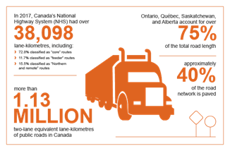
The map of Canada shows the location of the National Highway System (NHS). The NHS includes over 38,000 kilometers of Canada’s most important highways from coast to coast. Core routes (which represent 72.8 per cent of the NHS) are illustrated by orange lines, Feeder routes (which represent 11.7% of the NHS) by Yellow lines and Northern and Remote routes (which represent 15.5 per cent of the NHS) by purple lines.
Key traffic and volume statistics
Road transportation is the primary mode for moving both freight and passengers across Canada. Canada is connected from the Pacific to Atlantic coasts by a network of highways, anchored by the Trans-Canada Highway. Canada also has extensive road networks across the southern, more populated areas.
In 2021, 26.2 million road motor vehicles were registered in Canada, up 1.9% from 2020 and 17.2% from a decade ago. Around 91.9% were vehicles weighed less than 4,535 kilograms, mainly passenger automobiles, pickups, SUVs, and minivans, 4.7% were medium and heavy trucks weighing 4,535 kilograms or more, and 3.4% were other vehicles such as buses, motorcycles and mopeds.
As of December 2022, there were 136,664 trucking businesses. 52,766 of these companies had employees and 83,898 didn’t. The trucking industry includes many small for-hire carriers and owner-operators, and some medium and large for-hire companies that operate fleets of trucks and offer logistic services. Trucking companies are mostly located in Ontario (48.3%), Quebec (14.9%), Alberta (14.5%), and British Columbia (10.9%).